Polšnik
| Polšnik | |
|---|---|
 | |
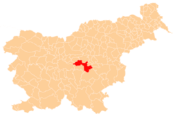
_location_map.svg.png) Polšnik Location in Slovenia | |
| Coordinates: 46°4′7″N 14°57′39″E / 46.06861°N 14.96083°ECoordinates: 46°4′7″N 14°57′39″E / 46.06861°N 14.96083°E | |
| Country |
|
| Traditional region | Lower Carniola |
| Statistical region | Central Slovenia |
| Municipality | Litija |
| Area | |
| • Total | 8.08 km2 (3.12 sq mi) |
| Elevation | 664.4 m (2,179.8 ft) |
| Population (2002) | |
| • Total | 122 |
| [1] | |
Polšnik (pronounced [ˈpoːu̯ʃnik]; German: Billichberg[2]) is a settlement in the Municipality of Litija in central Slovenia. Traditionally the area was part of Lower Carniola and is now included with the rest of the municipality in the Central Slovenia Statistical Region.[3] Together with the two parts of the main settlement (Zgornji Polšnik 'Upper Polšnik', German: Oberbillichberg[2] and Spodnji Polšnik 'Lower Polšnik', German: Unterbillichberg[2]) it also includes the hamlets of Na Puši, Seruč, Koprivnik, Slop, Glinjek, Velika Njiva (Slovene: Velika njiva), and Sušje.[4]
The local parish church is dedicated to Our Lady of Lourdes and belongs to the Roman Catholic Archdiocese of Ljubljana. It was designed by Franc Avsec[4] and built in 1904 with an octagonal nave.[5] A second church, built on Glinjek Hill (828 m) south of the main settlement, belongs to the same parish. It is dedicated to Saint George (Slovene: sveti Jurij) and originally dates to the 13th century. It was restyled in the 19th century, but retains some of its original features.[6]
References
- ↑ Statistical Office of the Republic of Slovenia
- ↑ 2.0 2.1 2.2 Leksikon občin kraljestev in dežel zastopanih v državnem zboru, vol. 6: Kranjsko. 1906. Vienna: C. Kr. Dvorna in Državna Tiskarna, p. 94.
- ↑ Litija municipal site
- ↑ 4.0 4.1 Savnik, Roman, ed. 1971. Krajevni leksikon Slovenije, vol. 2. Ljubljana: Državna založba Slovenije. p. 276.
- ↑ Slovenian Ministry of Culture register of national heritage reference number ešd 2155
- ↑ Slovenian Ministry of Culture register of national heritage reference number ešd 2160
