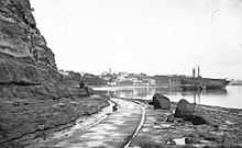
Point Britomart


Point Britomart is a former headland in the Waitemata Harbour, Auckland, New Zealand. Located between Commercial Bay and Official Bay,[1] it was later quarried away to produce fill for land reclamation in Mechanics Bay, and no physical trace remains at street level in what is today an area of the Auckland CBD and Auckland waterfront.
History
Point Britomart was the site of at least one Māori pā (fort), and considered an important site in the Auckland Isthmus, with several known battles fought over it, such as by the Ngāti Whātua in the 17th and 18th centuries.[2]
The point received its European name in 1848 from the HMS Britomart, whose crew undertook a detailed survey of the Waitemata Harbour after it had been decided to base the new capital here.[2] It was the site where the Union Jack was first raised in Auckland on 18 September 1840 by Felton Mathew after a preliminary agreement had been signed for the purchase of Auckland, and the point soon became the site of one of the first British military fortifications in New Zealand, Fort Britomart.[1]
Later on, in the 1870s and 1880s, it was quarried away for fill in Mechanics Bay, its spoils providing the land for a new railway station. The removal also made Official Bay more easily accessible by foot.[1]
The original Point Britomart area later also held a railway station and the General Post Office. At the turn of the millennium, in 2001 it became the site of the new Britomart Transport Centre.
References
- ↑ 1.0 1.1 1.2 Auckland's waterfront and its changing face (Auckland City Library, includes various further references)
- ↑ 2.0 2.1 Chapter 1 - The Historic Land 1600-1959 (from the Britomart Transport Centre website)
Coordinates: 36°50′39″S 174°46′20″E / 36.844049°S 174.772178°E