Podlehnik
| Podlehnik Občina Podlehnik | |
|---|---|
| Town and Municipality | |
|
Postcard of Podlehnik | |
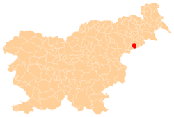 Location of the Municipality of Podlehnik in Slovenia | |
_location_map.svg.png) Podlehnik Location of the Town of Podlehnik in Slovenia | |
| Coordinates: 46°20′N 15°53′E / 46.333°N 15.883°ECoordinates: 46°20′N 15°53′E / 46.333°N 15.883°E | |
| Country |
|
| Government | |
| • Mayor | Marko Maučič |
| Area | |
| • Total | 46.0 km2 (17.8 sq mi) |
| Population (2002)[1] | |
| • Total | 1,820 |
| • Density | 40/km2 (100/sq mi) |
| Time zone | CET (UTC+01) |
| • Summer (DST) | CEST (UTC+02) |

Podlehnik is a settlement and a municipality in the Haloze hills in eastern Slovenia. The area traditionally belonged to the region of Styria. It is now included in the Drava statistical region.[2]
The settlement developed around 13th-century Lehnik Castle. The castle was destroyed during Ottoman raids in 1532 and very few traces of it remain (foundations of a tower and a defense ditch).[3] What was originally the castle chapel is now the local church, dedicated to the Virgin Mary, and was expanded in the 16th and 18th centuries.[4]
References
External links
| ||||||||||||