Pocklington Reef
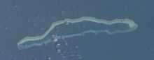 ISS image of Pocklington Reef | |
 Pocklington Reef (Papua New Guinea) | |
| Geography | |
|---|---|
| Location | Solomon Sea |
| Coordinates | 10°48′44″S 155°44′18″E / 10.81222°S 155.73833°E |
| Area | 0.01 km2 (0.0039 sq mi) |
| Highest elevation | 3 m (10 ft) |
| Highest point | unnamed |
| Country | |
|
Papua New Guinea | |
| Province |
|
| District | Samarai-Murua District |
| LLG | Louisiade Rural Local Level Government Area |
| Additional information | |
| Atoll | |
Coordinates: 10°48′44″S 155°44′18″E / 10.81222°S 155.73833°E Pocklington Reef is a coral reef and a mostly submerged atoll in the far southeast of Papua New Guinea.
It is 162.4 km from the closest island, Loa Boloba, which is a tiny coral islet within the fringing reef near Cape Deliverance, the south east point of Rossel Island (Yela) in the Louisiade Archipelago, and belongs to Milne Bay province, Samarai-Murua District, Louisiade Rural Local Level Government Area.
Pocklington Reef sits on top of Pocklington Ridge, which extends northeast from Rossel Island. The reef is 32 km long and up to 4 km wide. Its longer axis is northeast-southwest. The rim of the reef encloses a deep lagoon. The northern rim reaches closer to the surface, and several above water rocks with heights between 0.9 and 3 metres high lie along its length. There is a small spit of sand about the size of a football field (less than one hectare) at the northeast end. There is a shipwreck at that location.[1]
On 28 April 1962, Panamanian SS Dona Ourania grounded on Pocklington Reef.[2]
Pocklington Reef Marine Park is a proposed marine protected area.[3]
References
- ↑ http://permanent.access.gpo.gov/websites/pollux/pollux.nss.nima.mil/NAV_PUBS/SD/pub164/164sec08.pdf
- ↑ http://books.google.com/books?id=tpo9AAAAIAAJ&pg=PA40&lpg=PA40&dq=%22Pocklington+Reef%22&source=web&ots=_dWQuJkqs4&sig=bvxhGPmAA-Qh0Hows-7WMzAFt6g&hl=en&sa=X&oi=book_result&resnum=37&ct=result
- ↑ http://www.mpaglobal.org/index.php?action=showMain&site_code=15924
External links
- Satellite image at the Wayback Machine (archived December 23, 2010)
- Maritime boundaries
- Papua New Guinea Act
Category;Coral reefs