Plourin-lès-Morlaix
| Plourin-lès-Morlaix | |
|---|---|
|
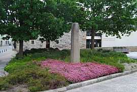
Plourin Menhir : Once a milestone on the Roman road. | |
 Plourin-lès-Morlaix | |
|
Location within Brittany region  Plourin-lès-Morlaix | |
| Coordinates: 48°32′07″N 3°47′22″W / 48.5353°N 3.7894°WCoordinates: 48°32′07″N 3°47′22″W / 48.5353°N 3.7894°W | |
| Country | France |
| Region | Brittany |
| Department | Finistère |
| Arrondissement | Morlaix |
| Canton | Morlaix |
| Intercommunality | Morlaix |
| Government | |
| • Mayor (2014–2020) | Guy Pennec |
| Area1 | 40.92 km2 (15.80 sq mi) |
| Population (2008)2 | 4,538 |
| • Density | 110/km2 (290/sq mi) |
| INSEE/Postal code | 29207 / 29600 |
| Elevation | 8–242 m (26–794 ft) |
|
1 French Land Register data, which excludes lakes, ponds, glaciers > 1 km² (0.386 sq mi or 247 acres) and river estuaries. 2 Population without double counting: residents of multiple communes (e.g., students and military personnel) only counted once. | |
Plourin-lès-Morlaix (Breton: Plourin-Montroulez) is a commune in the Finistère department of Brittany in north-western France.
Population
Inhabitants of Plourin-lès-Morlaix are called in French Plourinois.
| Historical population | ||
|---|---|---|
| Year | Pop. | ±% |
| 1793 | 2,230 | — |
| 1800 | 1,860 | −16.6% |
| 1806 | 2,168 | +16.6% |
| 1821 | 2,720 | +25.5% |
| 1831 | 3,020 | +11.0% |
| 1836 | 3,065 | +1.5% |
| 1841 | 3,070 | +0.2% |
| 1846 | 3,115 | +1.5% |
| 1851 | 3,121 | +0.2% |
| 1856 | 3,013 | −3.5% |
| 1861 | 3,145 | +4.4% |
| 1866 | 3,218 | +2.3% |
| 1872 | 3,109 | −3.4% |
| 1876 | 3,125 | +0.5% |
| 1881 | 2,988 | −4.4% |
| 1886 | 3,007 | +0.6% |
| 1891 | 2,900 | −3.6% |
| 1896 | 2,847 | −1.8% |
| 1901 | 2,718 | −4.5% |
| 1906 | 2,736 | +0.7% |
| 1911 | 2,637 | −3.6% |
| 1921 | 2,420 | −8.2% |
| 1926 | 2,364 | −2.3% |
| 1931 | 2,219 | −6.1% |
| 1936 | 2,192 | −1.2% |
| 1946 | 2,111 | −3.7% |
| 1954 | 2,002 | −5.2% |
| 1962 | 2,008 | +0.3% |
| 1968 | 2,348 | +16.9% |
| 1975 | 3,649 | +55.4% |
| 1982 | 4,311 | +18.1% |
| 1990 | 4,176 | −3.1% |
| 1999 | 4,250 | +1.8% |
| 2008 | 4,808 | +13.1% |
Sights
The church
The Notre Dame church backs up to the end of 17th century – beginning of 18th. The taxus next to the entrance is supposed to be one thousand years old.

Plourin lès Morlaix church (Feb 2010)
See also
- Communes of the Finistère department
- Roland Doré sculptor
- Plourin-lès-Morlaix Parish close
References
- Mayors of Finistère Association (French)
External links
| Wikimedia Commons has media related to Plourin-lès-Morlaix. |
- Official website (French)
- French Ministry of Culture list for Plourin-lès-Morlaix (French)
