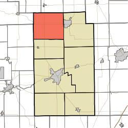
Pleasant Township, Wabash County, Indiana
| Pleasant Township | |
|---|---|
| Township | |
 Location in Wabash County | |
| Coordinates: 40°59′41″N 85°51′46″W / 40.99472°N 85.86278°WCoordinates: 40°59′41″N 85°51′46″W / 40.99472°N 85.86278°W | |
| Country | United States |
| State | Indiana |
| County | Wabash |
| Government | |
| • Type | Indiana township |
| Area | |
| • Total | 54.98 sq mi (142.4 km2) |
| • Land | 54.29 sq mi (140.6 km2) |
| • Water | 0.69 sq mi (1.8 km2) 1.26% |
| Elevation | 801 ft (244 m) |
| Population (2010) | |
| • Total | 2,412 |
| • Density | 44.4/sq mi (17.1/km2) |
| ZIP codes | 46943, 46962, 46974, 46982 |
| GNIS feature ID | 0453751 |
Pleasant Township is one of seven townships in Wabash County, Indiana, United States. As of the 2010 census, its population was 2,412 and it contained 1,020 housing units.[1]
Geography
According to the 2010 census, the township has a total area of 54.98 square miles (142.4 km2), of which 54.29 square miles (140.6 km2) (or 98.74%) is land and 0.69 square miles (1.8 km2) (or 1.26%) is water.[1]
Unincorporated towns
- Disko at 41°00′08″N 85°56′40″W / 41.002266°N 85.944436°W
- Ijamsville at 40°57′35″N 85°49′58″W / 40.959766°N 85.832765°W
- Laketon at 40°58′27″N 85°50′09″W / 40.974211°N 85.835821°W
- Newton at 40°58′02″N 85°49′17″W / 40.967267°N 85.821376°W
(This list is based on USGS data and may include former settlements.)
Adjacent townships
- Lake Township, Kosciusko County (north)
- Jackson Township, Kosciusko County (northeast)
- Chester Township (east)
- Paw Paw Township (south)
- Henry Township, Fulton County (west)
- Perry Township, Miami County (west)
- Seward Township, Kosciusko County (northwest)
Cemeteries
The township contains these three cemeteries: Laketon, Pleasant Hill and Shiloh.
Lakes
- Brown Lake
- Long Lake
- Lotz Lake
- Lukens Lake
- Mc Calley Lake
- Mud Lake
- Round Lake
School districts
- Manchester Community Schools
Political districts
- Indiana's 5th congressional district
- State House District 22
- State Senate District 18
References
- United States Census Bureau 2007 TIGER/Line Shapefiles
- United States Board on Geographic Names (GNIS)
- IndianaMap
- ↑ 1.0 1.1 "Population, Housing Units, Area, and Density: 2010 - County -- County Subdivision and Place -- 2010 Census Summary File 1". United States Census. Retrieved 2013-05-10.
External links
| |||||||||||||||||||||||||||||