Plateau
.jpg)

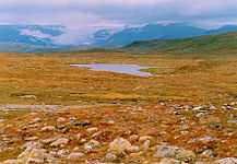
In geology and earth science, a plateau (/pləˈtoʊ/ or /ˈplætoʊ/; plural plateaus or plateaux), also called a high plain or tableland, is an area of highland, usually consisting of relatively flat terrain that is raised significantly above the surrounding area, often with one or more sides with steep slopes.
Formation
Plateaus can be formed by a number of processes, including upwelling of volcanic magma, extrusion of lava, and erosion by water and glaciers. Magma rises from the mantle causing the ground to swell upward, in this way large, flat areas of rock are uplifted. Plateaus can also be built up by lava spreading outward from cracks and weak areas in the crust. Plateaus can also be formed by the erosional processes of glaciers on mountain ranges, leaving them sitting between the mountain ranges. Water can also erode mountains and other landforms down into plateaus. Computer modeling studies suggest that high plateaus may also be partially a result from the feedback between tectonic deformation and dry climatic conditions created at the lee side of growing orogens.[1]
Classification
Plateaus are classified according to their surrounding environment.
- Intermontane plateaus are the highest in the world, bordered by mountains. The Tibetan Plateau is one such plateau.
- Piedmont plateaus are bordered on one side by mountains and on the other by a plain or sea.
- Continental plateaus are bordered on all sides by the plains or seas, forming away from mountains.
- Volcanic plateaus are produced by volcanic activity. The Columbia Plateau in the northwestern United States of America is one such plateau.
- Dissected plateaus are highly eroded plateaus cut by rivers and broken by deep narrow valleys.
Major plateaus
The largest and highest plateau in the world is the Tibetan Plateau, called the "roof of the world", which is still being formed by the collisions of the Indo-Australian and Eurasian tectonic plates. The Tibetan plateau covers approximately 2,500,000 km2 (970,000 sq mi), at about 5,000 m (16,000 ft) above sea level. The plateau is sufficiently high enough to reverse the Hadley cell convection cycles and to drive the monsoons of India towards the south.
The second-highest plateau is Deosai National Park (also known as Deoasai Plains) at an average elevation of 4,114 m (13,497 ft) and is located in the Skardu District of Gilgit-Baltistan, in northern Pakistan. Deosai means 'the land of giants'. The park protects an area of 3,000 km2 (1,200 sq mi). It is known for its rich flora and fauna of the Karakoram-West Tibetan Plateau alpine steppe ecoregion. In spring it is covered by sweeps wildflowers and a wide variety of butterflies. The highest point in Deosai is Deosai Lake, or Sheosar Lake from the Shina language meaning "Blind lake" (Sheo - Blind, Sar - lake) near the Chilim Valley. The lake lies at an elevation of 4,142 m (13,589 ft), one of the highest lakes in the world, and is 2.3 km (1.4 mi) long, 1.8 km (1.1 mi) wide, and 40 m (130 ft) deep on average.
The third-largest plateau is the Antarctic Plateau, which covers most of central Antarctica, where there are no known mountains, but rather 3,000 m (9,800 ft) or more of ice - which very slowly spreads toward the coastline via enormous glaciers. This ice cap is so massive that echolocation sound measurements of the thickness of the ice have shown that large parts of the "dry land" surface of Antarctica have been pressed below sea level. Thus, if the icecap were suddenly removed, large areas of Antarctica would be flooded by the oceans. On the other hand - more realistically - were the icecap to gradually melt away, the surface of the land beneath it would gradually rebound/[Isostasy] away from the center of the Earth, and that land would ultimately rise above sea level.
North America
The largest plateau in North America is the Colorado Plateau, which covers about 337,000 km2 (130,000 sq mi) in Colorado, Utah, Arizona and New Mexico.[2]
In northern Arizona and southern Utah the Colorado Plateau is bisected by the Colorado River and the Grand Canyon. How this came to be is that over 10 million years ago, a river was already there, though not necessarily on exactly the same course. Then, subterranean geological forces caused the land in that part of North America to gradually rise by about a centimeter per year for millions of years. An unusual balance occurred: the river that would become the Colorado River was able to erode into the crust of the Earth at a nearly equal rate to the uplift of the plateau. Now, millions of years later, the North Rim of the Grand Canyon is at an elevation of about 2,450 m (8,040 ft) above sea level, and the South Rim of the Grand Canyon is about 2,150 m (7,050 ft) above sea level. At its deepest, the Colorado River is about 1,830 m (6,000 ft) below the level of the North Rim
South America
A tepui /ˈtɛpwi/, or tepuy (Spanish: [teˈpui]), is a table-top mountain or mesa found in the Guiana Highlands of South America, especially in Venezuela and western Guyana. The word tepui means "house of the gods" in the native tongue of the Pemon, the indigenous people who inhabit the Gran Sabana.
Tepuis tend to be found as isolated entities rather than in connected ranges, which makes them the host of a unique array of endemic plant and animal species. Some of the most outstanding tepuis are Neblina, Autana, Auyantepui and Mount Roraima. They are typically composed of sheer blocks of Precambrian quartz arenite sandstone that rise abruptly from the jungle, giving rise to spectacular natural scenery. Auyantepui is the source of Angel Falls, the world's tallest waterfall.
See also
| Wikimedia Commons has media related to Plateaus. |
- Atherton Tableland
- Butte
- Chapada
- Deosai National Park
- Mesa
- Oceanic plateau for submarine or undersea plateaux
- Potrero
- Tepuis
- Tuya
References
- ↑ Garcia-Castellanos, D., 2007. The role of climate during high plateau formation. Insights from numerical experiments. Earth Planet. Sci. Lett. 257, 372-390, doi:10.1016/j.epsl.2007.02.039 pdf
- ↑ Leighty, Dr. Robert D. (2001). "Colorado Plateau Physiographic Province". Contract Report. Defense Advanced Research Projects Agency (DOD) Information Sciences Office. Retrieved 2007-12-25.
External links
- "Plateau" at scienceclarified.com
- nationalgeographic.com
- travel-university.org
- edu.pe.ca
- britannica.com
| ||||||||||||||||||||||||||||||||||||||||||||||