Piz Giuv
| Piz Giuv | |
|---|---|
| Schattig Wichel | |
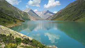 View from Lake Curnera, Piz Giuv lies behind the lower summit of the Crispalt (centre left) | |
| Elevation | 3,096 m (10,157 ft) |
| Prominence | 749 m (2,457 ft)[1] |
| Parent peak | Tödi |
| Location | |
 Piz Giuv Location in Switzerland | |
| Location | Uri/Graubünden, Switzerland |
| Range | Glarus Alps[2] |
| Coordinates | 46°42′07″N 8°41′33″E / 46.70194°N 8.69250°ECoordinates: 46°42′07″N 8°41′33″E / 46.70194°N 8.69250°E |
Piz Giuv (or Schattig Wichel) is a mountain of the Glarus Alps, located on the border between the cantons of Uri and Graubünden. At 3,096 metres above sea level, it is the highest mountain of the Glarus Alps lying west of the Oberalpstock. Its summit is situated between three valleys: the Fellital and Etzlital on the north side and the Val Giuv (Surselva) on the south side. The slightly lower Piz Nair lies on its east side
References
- ↑ Retrieved from the Swisstopo topographic maps. The key col is the Chrüzlipass (2,347 m).
- ↑ John Ball, The Alpine Guide, Central Alps, 1866, London