Pitt Island
| Rangiaotea (Moriori) Rangiauria (Māori) | |
|---|---|
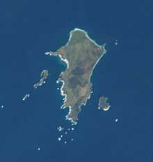 Pitt Island from space | |
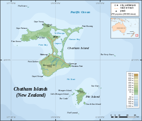 Map showing location of Pitt Island. | |
| Geography | |
| Coordinates | 44°17′S 176°13′W / 44.283°S 176.217°WCoordinates: 44°17′S 176°13′W / 44.283°S 176.217°W |
| Archipelago | Chatham Islands |
| Area | 65 km2 (25 sq mi) |
| Country | |
Pitt Island is the second largest island in the Chatham Archipelago, a territory of New Zealand. It is called Rangiauria in Māori and Rangiaotea in Moriori.[1]
Pitt Island has 65 square kilometres (25 sq mi). It lies about 770 kilometres (480 mi) [2]to the east of New Zealand's main islands, and about 20 kilometres (12 mi) to the southeast of Chatham Island, from which it is separated by Pitt Strait. The island is very hilly; its highest point (Waihere Head) rises to 231 metres (758 ft) above sea level.[3] As of 2011, Pitt Island had a population of about 38 people.
Pitt Island's Kahuitara Point is the first populated location on earth to observe a sunrise in each new year, based on local time zone.[4]
History
Pitt Island was originally inhabited by the Moriori, the indigenous peoples of the Chatham Islands, who called it Rangiaotea or Rangihaute. Their archaeological remains are found almost everywhere on the island; large quantities of artifacts are constantly coming to light.[5][6] No remains of momori rakau are visible on the island, but there are records of them once being present[7]
The first Europeans to see the island were the crew of William R. Broughton's ship HMS Chatham, who spotted it in 1791. It was named for William Pitt, 1st Earl of Chatham. Fifty years later the name was simplified to "Pitt" Island.
The Taranaki Maori who invaded the Chatham Island islands called it Rangiauria, a name which is still in use today.
Over the years there have been many ships wrecked around both Pitt and Chatham Islands. The Glory, a small brigantine was wrecked in what became known as Glory Bay in 1827.
Economy and facilities
The main sources of income for Pitt Islanders are farming, commercial fishing, and tourism. The New Zealand Department of Conservation is active on Pitt Island and, in conjunction with several landowners, administers a number of covenanted areas and reserves. The island imports fuel and most manufactured goods, and exports live sheep and cattle to mainland New Zealand.
The island has a school, a wharf, a church and a landing strip for light planes. A gravel road runs from Flower Pot Bay to the grass air strip. A supply ship visits Pitt Island about every three months. Each household generates its own electricity, by either diesel generator or wind turbine, Most homes have satellite TV and broadband internet connections. Transport on the island was mostly by means of quad bikes, four wheel drives and occasionally horses. The Pitt Island School had in 2011 eight children aged between 6 and 12 years.
Fauna and flora
On Pitt Island there are several flocks of feral Saxon Merino sheep.
See also
References
- ↑ Government of New Zealand, Dept. of Conservation (1999) Chatham IslandsConservation Management Strategy, map 6. Accessed on 2012-07-13.
- ↑ "Chatham Islands Page 1 Overview". web page. The Encyclopedia of New Zealand. 7 September 2012. Retrieved 15 December 2012.
- ↑ "Chatham Islands Page 1 Overview". web page. The Encyclopedia of New Zealand. 7 September 2012. Retrieved 15 December 2012.
- ↑ "First Sunrise of the New Millennium". Astronomical Applications Department, U.S. Naval Observatory.
- ↑ King 2000.
- ↑ http://www.education-resources.co.nz/
- ↑ King 2000
External links
- Moriori Education Resources Online
- Official Moriori Website With Information on Pitt Island Moriori
| ||||||||||||||||