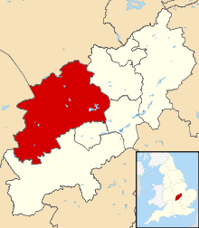
Pitsford
| Pitsford | |
 Pitsford |
|
| Population | 636 |
|---|---|
| OS grid reference | SP7568 |
| District | Daventry |
| Shire county | Northamptonshire |
| Region | East Midlands |
| Country | England |
| Sovereign state | United Kingdom |
| Post town | Northampton |
| Postcode district | NN6 |
| Dialling code | 01604 |
| Police | Northamptonshire |
| Fire | Northamptonshire |
| Ambulance | East Midlands |
| EU Parliament | East Midlands |
| UK Parliament | Kettering |
|
|
Coordinates: 52°18′23″N 0°53′34″W / 52.3064°N 0.8927°W
Pitsford is a village and civil parish in the Daventry District of the non-metropolitan county of Northamptonshire in the United Kingdom. According to 2001 census, the parish's population was 636 people.[1] There is one pub, The Griffin, situated in the high street, which is a listed building.[2]
Pitsford Water, which is used for fishing and sailing as well as storing water for the local area,[3] is north-west of the village, but only part of it lies within the parish.[4] Pitsford Airstrip is at Moulton Grange Farm. Pitsford Hall is home to Pitsford School,[5] which runs Pitsford Hall weather station. Ironstone is quarried at Pitsford and was formerly transported by rail; the railway line is now part of the preserved Northampton & Lamport Railway which has its headquarters at Pitsford and Brampton railway station. Henry Watkin, the utopian socialist, was born in the village in 1824.
References
- ↑ Office for National Statistics: Pitsford CP: Parish headcounts. Retrieved 16 November 2009
- ↑ "Griffin Inn - Pitsford - Northamptonshire - England | British Listed Buildings:". BritishListedBuildings.co.uk. Retrieved 5 August 2010.
- ↑ Anglian Water: Pitsford Water Park. Retrieved 16 November 2009
- ↑ Ordnance Survey 1:25,000 mapping
- ↑ Pitsford School - About us - School history. Retrieved 7 July 2012
External links
| Wikimedia Commons has media related to Pitsford. |
- Information about the parish church
- Map sources for Pitsford
