Pithole Creek
| Pithole Creek | |
| Stream | |
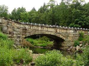
 Pithole Creek at the Pithole Stone Arch Bridge | |
| Country | United States |
|---|---|
| State | Pennsylvania |
| Counties | Forest |
| Source | |
| - location | Stewart Run, Forest County, Pennsylvania |
| - elevation | 1,720 ft (524 m) [1] |
| - coordinates | 41°37′20″N 79°29′38″W / 41.62222°N 79.49389°W [2] |
| Mouth | Allegheny River |
| - location | Oleopolis, Venango County, Pennsylvania |
| - elevation | 1,010 ft (308 m) [1] |
| - coordinates | 41°27′23″N 79°36′35″W / 41.45639°N 79.60972°WCoordinates: 41°27′23″N 79°36′35″W / 41.45639°N 79.60972°W [2] |
| Length | 17.1 mi (28 km) [1] |
| Basin | 41.8 sq mi (108 km2) [1] |
|
Location of the mouth of Pithole Creek in Pennsylvania
| |
Pithole Creek is a 17.1-mile (27.5 km) tributary of the Allegheny River in Northwest Pennsylvania in the United States.[3] It has a drainage area of 41.8 square miles (108 km2).
Pithole Creek joins the Allegheny River approximately 0.5 miles (0.80 km) upstream of Oleopolis.[3]
See also
References
- ↑ 1.0 1.1 1.2 1.3 Shaw, L. C.; W. F. Busch (June 1984). Pennsylvania Gazetteer of Streams, Part II. Water Resources Bulletin 16. Prepared in Cooperation with the United States Department of the Interior Geological Survey. Harrisburg, PA: Pennsylvania Department of Forest and Waters.
- ↑ 2.0 2.1 "Pithole Creek". Geographic Names Information System. August 2, 1979. Retrieved February 13, 2009.
- ↑ 3.0 3.1 Gertler, Edward. Keystone Canoeing, Seneca Press, 2004. ISBN 0-9749692-0-6