Pingelap
| Pingelap | |
|---|---|
| Atoll | |
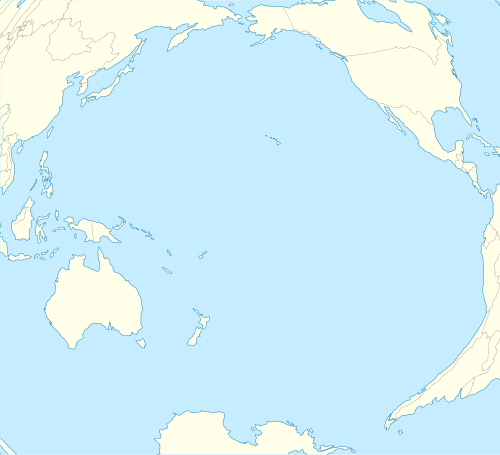 Pingelap Location of Pigelap in the Pacific | |
| Coordinates: 6°13′5″N 160°42′10″E / 6.21806°N 160.70278°ECoordinates: 6°13′5″N 160°42′10″E / 6.21806°N 160.70278°E | |
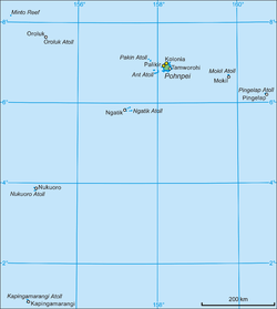
| Country | Micronesia |
| State | Pohnpei |
| Area | |
| • Land | 1.8 km2 (0.7 sq mi) |
| Dimensions | |
| • Width | 4 km (2 mi) |
| Population | |
| • Total | 250 |
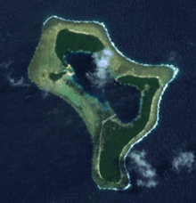
Pingelap is an atoll in the Pacific Ocean, part of Pohnpei State of the Federated States of Micronesia, consisting of three islands: Pingelap Island, Sukoru and Daekae, linked by a reef system and surrounding a central lagoon, although only Pingelap Island is inhabited.[1] The entire system has a land area of 1.8 km² (455 acres) at high-tide, and is less than 2.5 miles (4.0 km) at its widest point.[2] The atoll has its own language, Pingelapese, spoken by most of the atoll's 250 residents.
History
The first European discoverer of the islands was Captain Thomas Musgrave in Sugar Cane. Captain MacAskill in the Lady Barlow rediscovered them in 1809. Errors in measurement of their location resulted in the islands being separately named on charts in the 19th century as the Musgrave Islands and the MacAskill islands, within the Caroline archipelago.[3][4]
Japan seized the atoll in October 1914, following the start of World War I. Japan then occupied the southern part of Pingelap Island during hostilities in the Pacific Ocean theater of World War II for a supply base. Allied Forces later attacked it. The presence of foreign troops on the island led to the introduction of a number of infectious diseases, including gonorrhoea, tuberculosis and dysentery, which reduced the population from its pre-war level of around 1000 to 800, and decreased the fertility rate significantly.[1]
Historically, the atoll was ruled by a paramount chief known as the nahnmariki; a hereditary title that granted certain land rights to its holder. This system remained in place during Japanese rule, although the title was renamed "Island Magistrate". However, with the arrival of the U.S. Navy in 1945, a democratically-elected system was set up alongside the traditional system, which gradually weakened in power. Universal primary education was provided for Pingelapese children and a limited health care scheme was set up to eradicate the diseases introduced during the war.[1]
During the 1960s, the Peace Corps and U.S. Air Force settled on the main island, constructing a missile watching station in the northeast of the island and a pier, with work beginning in 1978 on an airstrip, jutting into the lagoon, on the main island.[1] The runway was finished in 1982, and currently between 2 and 3 planes per day fly to and from the atoll, operated by Caroline Islands Air.[5]
Climate
Pingelap enjoys a tropical climate, with even, warm temperatures throughout the year.
Precipitation is generally plentiful, with heavy year-round rainfall.
Color-blindness
A significant proportion, 4.92%,[6] of the population have complete achromatopsia (known on the island as maskun, meaning literally "not see" in Pingelapese), a recessive genetic disorder that causes total color-blindness in sufferers.[7]
Complete achromatopsia is normally a very rare condition, and its prevalence on the island has been traced back to a population bottleneck in 1775 after a catastrophic typhoon swept through the island, leaving only about 20 survivors.[8] One of these, Nanmwarki Mwanenihsed (the ruler at that time), is now believed to have been a carrier for the underlying genetic condition, but the achromatopsia disorder did not appear until the fourth generation after the typhoon, by which time 2.70% of the Pingelapese were affected. Since achromatopsia is an autosomal recessive disorder, inbreeding between the descendants of Nahnmwarki Mwanenised would result in an increased recessive allele frequency.[9] By generation 6, the incidence rose to approximately 4.92%,[10] due to the founder effect and inbreeding, with all achromats on the island nowadays tracing their ancestry to Nanmwarki Mwanenihsed.
Today the atoll is still of particular interest to geneticists; due to the small gene pool and rapid population growth, the disorder is now prevalent in almost 10% of the population, with a further 30% being unaffected carriers (by comparison, in the United States, only 1 in 33,000, or 0.003%, are affected).[11] Leading neurologist Oliver Sacks's 1997 book The Island of the Colorblind[12] references the island.
References
| Wikimedia Commons has media related to Pingelap. |
- ↑ 1.0 1.1 1.2 1.3 Damas, David (1994). Bountiful Island: A Study of Land Tenure on a Micronesian Atoll. Wilfrid Laurier University Press. ISBN 0-88920-239-7.
- ↑ Damas, David (1985). "Pingelap Politics and American-Micronesian Relations". Ethnology (Ethnology, Vol. 24, No. 1) 24 (1): 43–55. doi:10.2307/3773489. JSTOR 3773489.
- ↑ Findlay (1851), Vol. 2, p.1076.
- ↑ Brigham (1900), Vol. 1, issue 2, p.131.
- ↑ "Micronesian Diary: Pingelap, Phonpei". intangible.org. Retrieved 2007-06-13.
- ↑ Hussels, I.E.; Mortons, N.E. (1972). "Pingelap and Mokil Atolls: achromatopsia". American Journal of Human Genetics 24 (3): 304–309. PMC 1762260. PMID 4555088.
- ↑ Morton, N.E.; Hussels, I.E.; Lew, R.; Little, G.F. (1972). "Pingelap and Mokil Atolls: historical genetics". American Journal of Human Genetics 24 (3): 277–289. PMC 1762283. PMID 4537352.
- ↑ "Gene Mutation for Color Blindness Found". Science News.
- ↑ Cabe, Paul R. (2004). "Inbreeding and Assortive Mating". Encyclopedia of genetics 2ed.
- ↑ Hussels, I.E.; Mortons, N.E. (1972). "Pingelap and Mokil Atolls: achromatopsia". American Journal of Human Genetics 24 (3): 304–309. PMC 1762260. PMID 4555088.
- ↑ "The Achromatopsia Group". Retrieved 2007-06-13.
- ↑ Sacks, Oliver (1997). The Island of the Colour-blind. Picador. ISBN 0-330-35887-1.
- Brigham, William Tufts (1900) An Index to the Islands of the Pacific Ocean: A Handbook to the Chart on the Walls of the Bernice Pauahi Bishop Museum of Polynesian Ethnology and Natural History. (Bishop Museum Press)
- Findlay, A.G. (1851; reprinted 2013) A Directory for the Navigation of the Pacific Ocean, with Descriptions of Its Coasts, Islands, Etc.: From the Strait of Magalhaens to the Arctic Sea, and Those of Asia and Australia. (Cambridge University). ISBN 9781108059732