Piney River (East Tennessee)
This article is about the Piney River of East Tennessee. For the river of the same name in Middle Tennessee, see Piney River (Middle Tennessee).
| Piney River | |
|---|---|
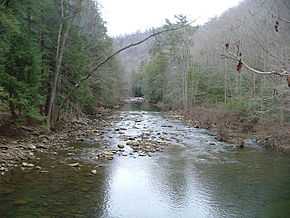 Upstream view from the Cumberland Trail bridge | |
| Origin | Confluence of Piney and Duskin Creeks |
| Mouth | Watts Bar Lake |
| Source elevation | ~ 1020 ft (311 m) [1] |
| Mouth elevation | 741 ft (226 m) [2] |
The Piney River is a stream that drains a portion of Tennessee's Cumberland Plateau generally referred to in the area as Walden Ridge. It rises near the Rhea County – Bledsoe County line and is referred to in its upper reaches, roughly until its confluence with Duskin Creek, as Piney Creek. Its major tributary, Little Piney Creek, flows over two spectacular but largely inaccessible waterfalls near the community of Grandview which are located in a State Natural Area. The confluence of the two streams occurs below the falls of the smaller stream in an area referred to as "Shut-in Gap". The stream flows out of the gap and is bridged by State Route 68 just before that road begins its steep climb up the Cumberland Escarpment onto Waldens Ridge. The stream flows north of Spring City, Tennessee, and just east of that town it becomes slack as an embayment of Watts Bar Lake, an impoundment of the Tennessee River formed by the Tennessee Valley Authority's Watts Bar Dam project. The mouth of the Piney is one of the larger embayments of Watts Bar Lake and contains several small islands.
Variant names
According to the Geographic Names Information System, Piney River has also been known historically as:[3]
- Piney Creek
- Pine River
See also
References
- ↑ U.S. Geological Survey. Pennine quadrangle, TN. 1:24,000. 7.5 Minute Series. Washington D.C.: USGS, 1990.
- ↑ U.S. Geological Survey. Spring City quadrangle, TN. 1:24,000. 7.5 Minute Series. Washington D.C.: USGS, 1990.
- ↑ U.S. Geological Survey Geographic Names Information System: Piney River
Coordinates: 35°39′14″N 84°46′59″W / 35.65396°N 84.78300°W