Pine Village, Indiana
| Pine Village | |
|---|---|
| Town | |
|
| |
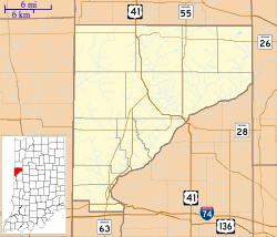 Pine Village Pine Village's location in Warren County | |
| Coordinates: 40°27′0″N 87°15′14″W / 40.45000°N 87.25389°WCoordinates: 40°27′0″N 87°15′14″W / 40.45000°N 87.25389°W | |
| Country | United States |
| State | Indiana |
| County | Warren |
| Township | Adams |
| Founded | 1851 |
| Founded by | Isaac and John Metsker |
| Named for | Big Pine Creek |
| Area[1] | |
| • Total | 0.12 sq mi (0.31 km2) |
| • Land | 0.12 sq mi (0.31 km2) |
| • Water | 0 sq mi (0 km2) |
| Elevation[2] | 692 ft (211 m) |
| Population (2010)[3] | |
| • Total | 217 |
| • Estimate (2012[4]) | 213 |
| • Density | 1,808.3/sq mi (698.2/km2) |
| Time zone | EST (UTC-5) |
| • Summer (DST) | EDT (UTC-4) |
| ZIP code | 47975 |
| Area code(s) | 765 |
| FIPS code | 18-60084[5] |
| GNIS feature ID | 0441164[6] |
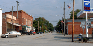
Pine Village is a town in Adams Township, Warren County, Indiana, United States. The population was 217 at the 2010 census.[3]
History
The town was founded at the location of a trading post called Pine Village, which may have been named for a lone pine tree that stood on the bluff of Pine Creek, or it may have been named for the creek itself.[7] The town was laid out in 1851 by Isaac and John R. Metsker, and the plat map was made by county surveyor Perrin Kent. The Methodist Church was already there; it was built several years earlier.[8]
Rail service
Rail service reached the town in the 1870s. The year 1883 witnessed the completion of a north/south Chicago and Great Southern Railway (later the Chicago and Indiana Coal Railway) line between Attica and Fair Oaks, some 50 miles (80 km) to the north. The line later was later part of the Chicago and Eastern Illinois Railroad. It came to be known as the "Coal Road" for the large quantities of coal transported along it. When the C&EI floundered in the early 1920s, Charles F. Propst purchased the Coal Road and in October 1922 incorporated it as the Chicago, Attica and Southern Railroad. The CA&S was placed in receivership on August 5, 1931, and incremental abandonment occurred over subsequent years.[9] The line through Pine Village was scrapped in the fall of 1945, and the rails where pulled up using a Belgian horse and a block and tackle.[10]
The area on the east side of Pine Village near the railroad, consisting of a grain elevator and some homes, was known as Oklahoma[10] and is located at 40°26′59″N 87°14′42″W / 40.44972°N 87.24500°W.
Professional football
During the mid-1910s, Pine Village hosted a prominent professional football team.
-
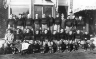
The football team of 1915
Geography
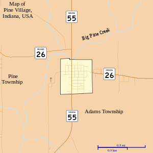
Pine Village is located at the intersection of State Road 55 and State Road 26, near Big Pine Creek.[11] It is about 20 miles (32 km) west of Lafayette and about 14 miles (23 km) east of the Illinois border.
According to the 2010 census, the town has a total area of 0.12 square miles (0.31 km2), all land.[1]
Demographics
2010 census
As of the censusof 2010,[3] there were 217 people, 104 households, and 47 families residing in the town. The population density was 1,808.3 inhabitants per square mile (698.2/km2). There were 117 housing units at an average density of 975.0 per square mile (376.4/km2). The racial makeup of the town was 99.1% White and 0.9% Asian. Hispanic or Latino of any race were 0.5% of the population.
There were 104 households of which 26.0% had children under the age of 18 living with them, 31.7% were married couples living together, 11.5% had a female householder with no husband present, 1.9% had a male householder with no wife present, and 54.8% were non-families. 44.2% of all households were made up of individuals and 22.1% had someone living alone who was 65 years of age or older. The average household size was 2.09 and the average family size was 3.02.
The median age in the town was 41.4 years. 20.7% of residents were under the age of 18; 8.3% were between the ages of 18 and 24; 28.2% were from 25 to 44; 24% were from 45 to 64; and 18.9% were 65 years of age or older. The gender makeup of the town was 48.8% male and 51.2% female.
2000 census
As of the census[5] of 2000, there were 255 people, 111 households, and 66 families residing in the town. The population density was 2,031.6 per square mile (757.4/km²). There were 118 housing units at an average density of 940.1/mi² (350.5/km²). The racial makeup of the town was 98.04% White and 1.96% Native American. Hispanic or Latino of any race were 0.78% of the population.
There were 111 households out of which 23.4% had children under the age of 18 living with them, 48.6% were married couples living together, 9.9% had a female householder with no husband present, and 40.5% were non-families. 35.1% of all households were made up of individuals and 10.8% had someone living alone who was 65 years of age or older. The average household size was 2.30 and the average family size was 3.02.
In the town the population was spread out with 24.3% under the age of 18, 5.1% from 18 to 24, 32.9% from 25 to 44, 20.4% from 45 to 64, and 17.3% who were 65 years of age or older. The median age was 38 years. For every 100 females there were 87.5 males. For every 100 females age 18 and over, there were 83.8 males.
The median income for a household in the town was $38,875, and the median income for a family was $43,750. Males had a median income of $37,813 versus $25,833 for females. The per capita income for the town was $18,952. About 6.3% of families and 7.1% of the population were below the poverty line, including 6.8% of those under the age of eighteen and 11.4% of those sixty five or over.
References
- ↑ 1.0 1.1 "Places: Indiana". 2010 Census Gazetteer Files. United States Census Bureau. Retrieved 2012-04-21.
- ↑ "USGS detail on Pine Village". Retrieved 2007-09-23.
- ↑ 3.0 3.1 3.2 "Profile of General Population and Housing Characteristics: 2010". United States Census Bureau. Retrieved 2013-11-24.
- ↑ "Population Estimates". United States Census Bureau. Retrieved 2013-06-25.
- ↑ 5.0 5.1 "American FactFinder". United States Census Bureau. Retrieved 2008-01-31.
- ↑ "US Board on Geographic Names". United States Geological Survey. 2007-10-25. Retrieved 2008-01-31.
- ↑ Baker, Ronald L.; Carmony, Marvin (1975). Indiana Place Names. Bloomington, Indiana: Indiana University Press. p. 130.
- ↑ A History of Warren County, Indiana. Warren County Historical Society. 1966. p. 6.
- ↑ Sulzer, Elmer G. (1998). "The Old Coal Road". Ghost Railroads of Indiana. Indiana University Press. ISBN 0-253-33483-7.
- ↑ 10.0 10.1 Rhode, Robert T. (1966). "A Walk Around Pine Village in the Early 1920s". A History of Warren County, Indiana. Warren County Historical Society.
- ↑ "US Gazetteer files: 2010, 2000, and 1990". United States Census Bureau. 2011-02-12. Retrieved 2011-04-23.
| |||||||||||||||||||||||||