Pine Level, Montgomery County, Alabama
| Pine Level, Alabama | |
|---|---|
| Unincorporated community | |
 Pine Level, Alabama | |
| Coordinates: 32°04′05″N 86°03′35″W / 32.06806°N 86.05972°WCoordinates: 32°04′05″N 86°03′35″W / 32.06806°N 86.05972°W | |
| Country | United States |
| State | Alabama |
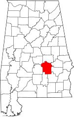
| County | Montgomery |
| Elevation | 489 ft (149 m) |
| Population (2007) | |
| • Total | 1,782 |
| Time zone | Central (CST) (UTC-6) |
| • Summer (DST) | CDT (UTC-5) |
| ZIP code | 36069 |
| Area code(s) | 334 |
| GNIS feature ID | 152926[1] |
Pine Level, also known as Pine Tucky, is an unincorporated community in Montgomery County, Alabama, United States. Pine Level is located along U.S. Route 231 and Alabama State Route 53 25 miles (40 km) southeast of Montgomery.
History
Pine Level was originally known as Pine Tucky, most likely due to its location on poor sandy soil covered with pine trees. The community later began to be called Pine Level.[2] A post office first opened under the name Pine Level in 1839.[3]
Notable people
- Rosa Parks, African-American Civil Rights activist, lived in Pine Level as a child
References
- ↑ "Pine Level". Geographic Names Information System. United States Geological Survey.
- ↑ Foscue, Virginia (1989). Place Names in Alabama. Tuscaloosa: The University of Alabama Press. p. 111. ISBN 0-8173-0410-X.
- ↑ "Montgomery County". Jim Forte Postal History. Retrieved 18 January 2015.
| |||||||||||||||||||||||||