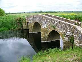
Pill Bridge
| Pill Bridge | |
|---|---|
 | |
| Coordinates | 51°00′28″N 2°42′50″W / 51.0077°N 2.7140°WCoordinates: 51°00′28″N 2°42′50″W / 51.0077°N 2.7140°W |
| Carries | pedestrian |
| Crosses | River Yeo |
| Locale | Between Ilchester and Long Sutton, Somerset, England |
| Heritage status | Scheduled monument |
| Characteristics | |
| Design | Arch bridge |
Pill Bridge is a stone arch bridge over the River Yeo between the parishes of Ilchester and Long Sutton, in the English county of Somerset. It is a scheduled monument.[1][2]
The current 17th century packhorse bridge replaced an earlier 13th century bridge at the same site.[2]
It was the unloading point for goods destined for Ilchester, 1.5 miles (2.4 km) downstream, until the conception of the Ivelchester and Langport Navigation. A warehouse at the site was used from 1699 until 1805.[2][3]
References
- ↑ "Pill Bridge, Long Sutton". British Listed Buildings. Retrieved 21 September 2014.
- ↑ 2.0 2.1 2.2 "Pill Bridge". Pastscape. English Heritage. Retrieved 22 November 2014.
- ↑ Baggs, A.P.; Bush, R.J.E; Tomlinson, Margaret. "Parishes: Ilchester". British History Online. Victoria County History. Retrieved 23 December 2014.