Piketberg
| Piketberg | |
|---|---|
|
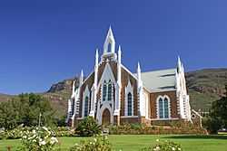
Church in Piketberg | |
 Piketberg
| |
| Coordinates: 32°54′S 18°46′E / 32.900°S 18.767°ECoordinates: 32°54′S 18°46′E / 32.900°S 18.767°E | |
| Country | South Africa |
| Province | Western Cape |
| District | West Coast |
| Municipality | Bergrivier |
| Established | 1840[1] |
| Area[2] | |
| • Total | 13.27 km2 (5.12 sq mi) |
| Population (2011)[2] | |
| • Total | 12,075 |
| • Density | 910/km2 (2,400/sq mi) |
| Racial makeup (2011)[2] | |
| • Black African | 8.1% |
| • Coloured | 76.4% |
| • Indian/Asian | 0.5% |
| • White | 14.3% |
| • Other | 0.7% |
| First languages (2011)[2] | |
| • Afrikaans | 92.7% |
| • Xhosa | 1.9% |
| • English | 1.8% |
| • Sotho | 1.2% |
| • Other | 2.4% |
| Postal code (street) | 7320 |
| PO box | 7320 |
| Area code | 022 |
Piketberg is a town in the Western Cape, South Africa. The original spelling of the name was "Piquetberg".
The town is in the foothills of the Piketberg mountains, a range of low mountains formed from Table Mountain Sandstone.
The area around the mountains is conducive to the farming of wheat, while the area on top of the mountains, being cooler and generally frost-free, is suited to the farming of fruit and Rooibos Tea.
Piketberg possesses a large white Dutch Reformed Church designed by the architect Carl Otto Hager in his trademark neo-Gothic style.[3]
The area was inhabited by the Khoikhoi and the San before the arrival of settlers of European extraction and there is still well-preserved San rock art in the mountains. There was once a small military post in the town to protect the livestock of farmers against depredations by the Khoikhoi.
References
- ↑ "Chronological order of town establishment in South Africa based on Floyd (1960:20-26)". pp. xlv–lii.
- ↑ 2.0 2.1 2.2 2.3 "Main Place Piketberg". Census 2011.
- ↑ "Piketberg Tourism and Accommodation: Visitor Information Centre". The Western Cape. Retrieved June 19, 2010.
External links
| |||||||||||||||||||||||||||||
.svg.png)