Pico 31 de Março
| Pico 31 de Março | |
|---|---|
|
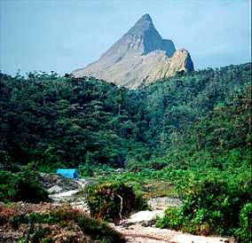
Pico 31 de Março is the small round blue-shaded summit behind its higher and sharper neighbour, Pico da Neblina, which is shown on the foreground. | |
| Elevation | 2,973 m (9,754 ft)[1] |
| Parent peak | Pico da Neblina |
| Location | |
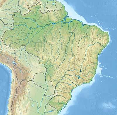 Pico 31 de Março Location on Brazil-Venezuela border | |
| Location |
|
| Range | Cerro de la Neblina, a section of Serra do Imeri in the Guiana Highlands |
| Coordinates | 0°48′N 66°00′W / 0.800°N 66.000°WCoordinates: 0°48′N 66°00′W / 0.800°N 66.000°W[1] |
| Climbing | |
| First ascent | 1965 |
| Easiest route | From the Brazilian town of São Gabriel da Cachoeira to Iazinho river by truck, then by boat on Iazinho river, Ia river, Caburaí river and Tucano river, then on a jungle trail with three camps (Tucano, Bebedouro Novo, Garimpo do Tucano) before the final ascent. This is the same route used for neighbouring Pico da Neblina. |
Pico 31 de Março (Portuguese pronunciation: [ˈpiku ˈtɾĩtɐ jũ dʒi ˈmaʁsu]), also known as Pico Phelps, is a mountain on the Brazil–Venezuela border. At 2,973 metres (9,754 ft) above sea level, it is Brazil's second highest mountain. It is part of the Cerro de la Neblina massif, and the latter peak, Brazil's highest summit, is only 687 m (2,254 ft) away. Pico 31 de Março can be considered a secondary summit of Pico da Neblina. Therefore, it is usually climbed by expeditions primarily aiming to reach the other peak. Pico 31 de Março is linked to Pico da Neblina by a col that can be easily traversed in a short trek of about an hour.
Discovery and naming
The peak was first discovered in 1954 by the Basset Maguire's expedition to the north side of the mountain massif. It was later climbed during the first attempt to climb Pico da Neblina, by a Brazilian army expedition. It received its name (meaning "March 31 Peak" in Portuguese) as a self-homage by the military regime instated in Brazil a few months earlier on that date, in a coup d'état which was then officially called the "March 31 Revolution." The peak was finally reached in the following year by another army expedition to Pico da Neblina. The name was not changed after Brazil returned to democratic rule in 1985. The peak is known as Pico Phelps in Venezuela.
Location
The Pico da Neblina is the highest point on the Guiana Shield, Neblina means "fog" in both Portuguese and Spanish. The mountains are contained in the Brazilian Pico da Neblina National Park; their northern slopes are also protected in Venezuela's Serranía de la Neblina National Park. The twin parks, together with the neighbouring Parima Tapirapecó National Park (Venezuela), form a protected area complex of about 80,000 km², possibly the largest national park system on tropical rainforests in the world.
Elevation measurements
For 39 years, based on a never before contested measurement performed in 1965 by topographer José Ambrósio de Miranda Pombo, using a theodolite, the elevation of Pico 31 de Março was thought to be 2,992 metres (9,816 feet), but a much more accurate measurement performed in 2004 with state-of-the-art GPS equipment by cartographer Marco Aurélio de Almeida Lima, member of a Brazilian army expedition, puts it at 2,973 metres (9,754 feet). This is now officially recognised by the Brazilian Institute of Geography and Statistics (IBGE), the federal government's official geographic survey and census agency, which jointly organised the expedition.
Geology and topography
The Cerro de la Neblina massif is a glaciated tor composed of a tilted block of sandstone overlying Precambrian metamorphic rocks. In contrast to the sharp tooth shape of its higher neighbour, Pico 31 de Março has a smoother shape and is sometimes difficult to be clearly distinguished from Pico da Neblina on photographs, depending on the angle and distance from which the photograph was taken. Due to its equatorial latitude, while it can be cold on top, sub-freezing temperatures and frost appear to be rare (no permanent measurements are undertaken), and there is no snow.
Access
Due to its location in a national park in a border area that is also part of Yanomami territory, access to the area is restricted and depends on a special permit by the Brazilian Institute of Environment and Renewable Natural Resources (IBAMA). The permit can be obtained at IBAMA's office in São Gabriel da Cachoeira, but all climbers must take an accredited local guide. A four-day trek each way should be expected, three of which consisting of a jungle trek in the rainforest that can be as hard and challenging as the climb itself. Rescue is close to impossible in the area.
Onchocerciasis or "river blindness," a parasitic disease that can cause permanent blindness and is transmitted by a black fly, is endemic in the area, albeit with a low incidence; malaria and yellow fever transmission are also possible. Therefore, climbers are advised not only to take the utmost precaution in avoiding insect bites, but also to discuss preventive and/or therapeutic strategies with their physicians.
See also
- Pico da Neblina National Park
- Guiana Highlands
References
- ↑ 1.0 1.1 "Pico 31 de Março". Peakbagger.com. Retrieved 2010-02-15.
- Maguire, Bassett and Reynolds, Charles D. (1955) "Cerro de la Neblina, Amazonas, Venezuela: A Newly discovered Sandstone Mountain" Geographical Review 45(1): pp. 27–51
- Instituto Brasileiro de Desenvolvimento Florestal (1979) Plano do Sistema de Unidades de Conservação do Brasil. Ministério da Agricultura (MA), Instituto Brasileiro de Desenvolvimento Florestal (IBDF) and Fundação Brasileira para a Conservação da Natureza (FBCN), Brasília, D.F., OCLC 6944034. In Portuguese, covers the geology, geomorphology, climate, soils, vegetation and fauna of Pico da Neblina National Park.
- Gentry, A.H. (1986) "Exploring the Mountain of the Mists" Science Year: The World Book Science Annual pp. 124–139
External links
- Best article of the 31 de March Peak, with the full article detailing the expedition, maps, tracklogs, camps, logistics and many photos (clubedosaventureiros.com)
- Picasa gallery of photographs from two Brazilian private expeditions to Pico da Neblina, maintained by Orlei S. Jr. of the Brazilian Mundo Vertical mountaineering site, where some pictures also show Pico 31 de Março as a rounded secondary peak. There is also a picture of Pico da Neblina taken from the top of 31 de Março, showing how close the two peaks are.
- "Pico 31 de Março" Peakbagger