Pico-Robertson
Pico-Robertson is a densely populated neighborhood in the Westside of Los Angeles, California.

Population
The 2000 U.S. census counted 18,019 residents in the 1,03-square-mile Pico-Robertson neighborhood—an average of 17,468 people per square mile, among the highest population densities for the city. In 2008, the city estimated that the population had increased to 19,253. The median age for residents was 36, older than the city at large; the percentages of residents aged 19 to 34 and 65 and older were among the county's highest.[1]
The neighborhood was considered "not especially diverse" ethnically. The breakdown was whites, 73.5%; Latinos, 7.3%;Asians, 5.7%; blacks, 5.6%; and others, 7.9%. Iran (37.2%) and Israel (5.7%) were the most common places of birth for the 34.6% of the residents who were born abroad—about the same percentage as in the city at large.[1]
The median yearly household income in 2008 dollars was $63,356, an average figure for Los Angeles. The average household size of 2.1 people was low for Los Angeles. Renters occupied 73.1% of the housing stock and house- or apartment owners held 26.9%.[1]
Geography
Description
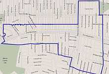
According to the Mapping L.A. project of the Los Angeles Times, Pico-Robertson is flanked on the north and northeast by Beverly Hills, on the east by Carthay and Mid-City, on the south by Mid-City, Beverlywood and Cheviot Hills and on the west by Beverly Hills.[2]
Pico-Robertson's street borders are: north, Gregory Way and Pico Boulevard,; northeast, LeDoux Road and Olympic Boulevard; east, La Cienega Boulevard,[1] south, Airdrome St., Hillcrest Country Club, Cashio and W. 18th Streets, west, Robertson Boulevard, Beverly Green Dr. and S. Roxbury Dr.
The smaller named areas within the Pico-Robertson neighborhood are Crestview and La Cienega Arts District.
Nearby places
Relation of Pico-Robertson to nearby places, not necessarily contiguous:[2]
Education
Forty-eight percent of residents aged 25 and older possessed a four-year degree in 2000, a high rate for both the city and the county. The percentages of those residents with a master's degree was considered high for the county.[1]
There are no public schools within Pico-Robertson. The Six private schools in the neighborhood are:[3]
- Bais Chaya Mushka Chabad, K-12, 9051 West Pico Boulevard
- Rabbi Jacob Pressman Academy, elementary, 1055 South La Cienega Boulevard
- St. Mary Magdalen Elementary School, 1223 South Corning Street
- YULA Boys High School, 9760 West Pico Boulevard
- Yeshiva of Los Angeles Girls High School, 1619 South Robertson Boulevard
- Yeshivat Ohr Chanoch Boys High School 9-12, 8906 W Pico Blvd
References
- ↑ 1.0 1.1 1.2 1.3 1.4 "Pico-Robertson," Mapping L.A., Los Angeles Times
- ↑ 2.0 2.1 Colored map, Mapping L.A., Los Angeles Times
- ↑ "Schools," Mapping L.A., Los Angeles Times
| |||||||||||||||||
| |||||||||||||||||||||


