Picket Range
| Picket Range | |
|---|---|
|
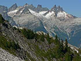
Mount Terror (left skyline), Inspiration Peak (center) and McMillan Spires (right center) from the south | |
| Highest point | |
| Peak | Luna Peak |
| Elevation | 8,311 ft (2,533 m) |
| Coordinates | 48°49′51″N 121°16′24″W / 48.83083°N 121.27333°WCoordinates: 48°49′51″N 121°16′24″W / 48.83083°N 121.27333°W |
| Geography | |
| Country | United States |
| State/Province | Washington |
The Picket Range is a small, extremely rugged subrange of the North Cascades in the northwestern part of the American state of Washington. It is entirely contained within North Cascades National Park. It is about 6 miles (9.7 km) long, running northwest-southeast, and lies north of the Skagit River, west of Ross Lake, and east of Mounts Baker and Shuksan. There are at least 21 peaks in the range over 7,500 ft (2,300 m) high .[1]
Swedish American Lage Wernstedt of the U.S. Forest Service mapped the Picket Range in the 1920s and named it for its resemblance to a picket fence (and not for George Pickett). Wernstedt was also apparently responsible for the names of the main peaks, including Mt. Challenger, Fury, Terror, and Phantom. These names first appeared on maps in 1931.[1]
There are few trails in the Picket Range, and any excursion there has a strong wilderness character. Many of the peaks are challenging rock climbs. The rock is biotite gneiss, "formed by metamorphism of sedimentary and volcanic rocks c. 100 m.y. ago."[1]
Highest Peaks of the Picket Range
| Mountain | Height | First ascent | |
|---|---|---|---|
| (ft) | (m) | ||
| Luna Peak | 8,311 | 2,533 | 1938 |
| Mount Fury | 8,292 | 2,527 | 1938 |
| Mount Challenger | 8,207 | 2,501 | 1936 |
| Mount Terror | 8,151 | 2,484 | 1932 |
| McMillan Spire | 8,004 | 2,440 | 1940 |
| Mount Degenhardt | 8,020 | 2,444 | 1931 |
| Whatcom Peak | 7,574 | 2,309 | 1936 |
| The Chopping Block | 6,819 | 2,078 | 1932 |
See also
References
- ↑ 1.0 1.1 1.2 Beckey, Fred W. (1995). Cascade Alpine Guide: Rainy Pass to Fraser River. The Mountaineers Books. pp. 94–128. ISBN 978-0-89886-423-6.
External links
| Wikimedia Commons has media related to Picket Range. |