Pic de Maupas
| Pic de Maupas | |
|---|---|
 | |
| Elevation | 3,109 m (10,200 ft) |
| Location | |
 Pic de Maupas Pyrenees | |
| Location | France–Spain border |
| Range | Pyrenees |
| Coordinates | 42°40′04″N 0°32′44″E / 42.66778°N 0.54556°ECoordinates: 42°40′04″N 0°32′44″E / 42.66778°N 0.54556°E |
| Geology | |
| Type | Granite |
| Climbing | |
| Easiest route | From refuge du Maupas |
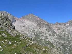
The pic de Maupas is a central pyrenean summit, culminating at 3,109 m (10,200 ft) on the Franco-Spanish border.
Toponymy
Maupas means « bad passage » because the passage from the Maupas glacier (today disappeared) and the submittal slope is a little awkward.
Geography
Il is located in Aragon in Spain and Haute-Garonne department (France), above Bagnères-de-Luchon.
Topography
Il domine le cirque des Crabioules et Superbagnères au nord, le vallon de Remugne au sud.
Geology
The summit is mainly granitic.
Access
There are many climbing routes. Access is possible on the eastern ridges (from le pic de Boum) and west (from le col des Crabioules, or by intermediate skying slopes). The standard route lies to the north via the refuge du Maupas, then the pass between la Tusse and le pic du Maupas.