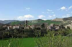
Piandimeleto
| Piandimeleto | ||
|---|---|---|
| Comune | ||
| Comune di Piandimeleto | ||
 | ||
| ||
 Piandimeleto Location of Piandimeleto in Italy | ||
| Coordinates: 43°44′N 12°25′E / 43.733°N 12.417°ECoordinates: 43°44′N 12°25′E / 43.733°N 12.417°E | ||
| Country | Italy | |
| Region | Marche | |
| Province | Province of Pesaro e Urbino (PU) | |
| Government | ||
| • Mayor | Riccardo Nonni | |
| Area | ||
| • Total | 40.0 km2 (15.4 sq mi) | |
| Population (28 February 2009[1]) | ||
| • Total | 2,112 | |
| • Density | 53/km2 (140/sq mi) | |
| Demonym | Pianmeletesi | |
| Time zone | CET (UTC+1) | |
| • Summer (DST) | CEST (UTC+2) | |
| Postal code | 61026 | |
| Dialing code | 0722 | |
| Patron saint | St. Blaise | |
| Saint day | 3 February | |

Piandimeleto is a comune (municipality) in the Province of Pesaro e Urbino in the Italian region Marche, located about 90 kilometres (56 mi) west of Ancona and about 45 kilometres (28 mi) southwest of Pesaro.
Piandimeleto borders the following municipalities: Belforte all'Isauro, Carpegna, Frontino, Lunano, Macerata Feltria, Pietrarubbia, Sant'Angelo in Vado, Sassocorvaro, Sestino, Urbino. Its territory is included in the Sasso Simone and Simoncello Regional Park. The Foglia river flows near the town.
References
- ↑ All demographics and other statistics: Italian statistical institute Istat.