Piñan, Zamboanga del Norte
| Piñan New Piñan | |
|---|---|
| Municipality | |
| Nickname(s): Inland resort capital of Zanorte | |
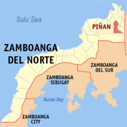
 Map of Zamboanga del Norte with Pi highlightedñan | |
.svg.png) Piñan Location within the Philippines | |
| Coordinates: 08°24′N 123°26′E / 8.400°N 123.433°ECoordinates: 08°24′N 123°26′E / 8.400°N 123.433°E | |
| Country | Philippines |
| Region | Zamboanga Peninsula (Region IX) |
| Province | Zamboanga del Norte |
| District | 1st district of Zamboanga del Norte |
| Founded | August 22, 1951 |
| Barangays | 22 |
| Government[1] | |
| • Mayor | Jose I. Belleno |
| Area[2] | |
| • Total | 93.75 km2 (36.20 sq mi) |
| Population (2010)[3] | |
| • Total | 20,088 |
| • Density | 210/km2 (550/sq mi) |
| Time zone | PST (UTC+8) |
| ZIP code | 7105 |
| Dialing code | 65 |
| Income class | 4th class |
Piñan is a fourth class municipality in the province of Zamboanga del Norte, Philippines. According to the 2010 census, it has a population of 20,088 people.[3]
Barangays
Piñan is politically subdivided into 22 barangays.[2]
- Bacuyong
- Bagong Silang
- Calican
- Del Pilar
- Desin
- Dilawa
- Dionum
- Lapu-lapu
- Lower Gumay
- Luzvilla
- Poblacion North
- Poblacion South
- Santa Fe
- Segabe
- Sikitan
- Silano
- Teresita
- Tinaytayan
- Ubay (Daan Tipan)
- Upper Gumay
- Villarico
Demographics
| Population census of Piñan | ||
|---|---|---|
| Year | Pop. | ±% p.a. |
| 1990 | 14,930 | — |
| 1995 | 19,447 | +5.08% |
| 2000 | 17,950 | −1.70% |
| 2007 | 18,669 | +0.54% |
| 2010 | 20,088 | +2.70% |
| Source: National Statistics Office[3] | ||
References
- ↑ "Official City/Municipal 2013 Election Results". Intramuros, Manila, Philippines: Commission on Elections (COMELEC). 12 May 2014. Retrieved 11 August 2014.
- ↑ 2.0 2.1 "Province: ZAMBOANGA DEL NORTE". PSGC Interactive. Makati City, Philippines: National Statistical Coordination Board. Retrieved 11 August 2014.
- ↑ 3.0 3.1 3.2 "Total Population by Province, City, Municipality and Barangay: as of May 1, 2010". 2010 Census of Population and Housing. National Statistics Office. Retrieved 11 August 2014.
External links
 |
Dapitan |  | ||
| Polanco Dipolog |
|
Mutia | ||
| ||||
| | ||||
| Sergio Osmeña Sr. |
| ||||||||||||||