Phu Kradueng National Park
| Phu Kradueng National Park | |
|---|---|
|
IUCN category II (national park) | |
|
View from Lom Sak Cliff on Phu Kradueng Mountain | |
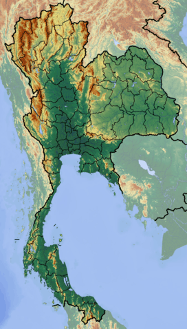 Location in Thailand | |
| Location | Loei Province, Thailand |
| Nearest city | Loei |
| Coordinates | 16°52′05″N 101°46′33″E / 16.86806°N 101.77583°ECoordinates: 16°52′05″N 101°46′33″E / 16.86806°N 101.77583°E |
| Area | 348 km² |
| Established | 1959 |
| Visitors | 69,613 (in 2009) |
| Governing body | Department of National Parks, Wildlife and Plant Conservation |

Phu Kradueng National Park (Thai: อุทยานแห่งชาติภูกระดึง), located in the Phu Kradueng mountain area, Amphoe Phu Kradueng of Loei Province, is one of the most famous national parks of Thailand, with a high point of 1316 m (4318 ft) above sea level. Every year tens of thousands of people come to make the climb up this famous mountain. It received the title of a nationally protected forest in the year 1943, and was proclaimed a national park on the 7th of October 1959, the second national park of Thailand after Khao Yai National Park.
The park is closed to visitors during the rainy season (1 June - 30 September).[1]
Topography
Phu Kradueng mountain, made up of Jurassic and Cretaceous sandstone formations, takes the form of a mesa towering some 1000 meters above the surrounding valleys. The summit plateau is roughly square-shaped and 60 km² in size, with an average elevation of about 1250 meters. Sloping slightly to the north, its western, southern and eastern edges are fairly straight and formed by abrupt sandstone cliffs, while the northern part is dissected into a more irregular shape, containing a number of streams and (seasonal) waterfalls. The summit itself, located in the southwestern part of the plateau, is inconspicuous.
Vegetation
The mountain's steep sides are home to a succession of tropical forest tiers, namely (in ascending order): Deciduous Dipterocarp, Mixed Deciduous, Dry Evergreen, and Hill Evergreen Forests, interspersed with bamboo. In contrast to that, the plateau at the mountain top consists of a sandy pine savanna landscape.
History
Phu (ภู) comes from the Thai word Phukao (ภูเขา), meaning mountain. The name Kradueng (กระดึง), or Krading (กระดิ่ง) in the local dialect of Loei Province, can be translated as Rakhang Yai (ระฆังใหญ่), meaning a large bell. This name comes from a legend relating to a Buddhist holiday. During the holiday many of the towns people heard the sound of a large bell. They believed it to be the bell of Indra.
The beauty of the mountain is reflected in local folk tales. One person named Phran, who fled from another village, believed that Phu Kradueng had never been climbed before. He led his bull to the top of the mountain. He found it full of beautiful deer, and pine forests. There were many different types of plants, trees and wild animals. After this he stayed, and lived his life surrounded by the beauty of the mountain.
Nowadays, Phu Kradueng is extremely popular with young Thais, particularly university students. Accommodation on the mountain itself is limited to a "tent city" with hundreds of canvas tents available for rent. The sense of isolation and scenic beauty is further spoilt by annoying and unnecessary loudspeakers intermittently announcing food availability, sleeping hours, and other concerns in Thai.
Travelling to Phu Kradueng
Autobus
The easiest route to Phu Kradueng is to take a bus from Khon Kaen to Pha Nok Kao. Get off in front of Ran Je Gim (ร้านเจ๊กิม). From there a minibus is available to take you to the central office of the park. The minibus takes approximately half an hour. The park office closes at 15:00, as climbers will not have enough time to climb the mountain before dark.
Park Trails
The Main Trail to the top from Amphoe Phu Kradueng
This is a very old and historic trail about 5.5 km in length, climbing the southeastern flank of the mountain. It starts from the main park office in Amphoe Phu Kradueng, at an elevation of about 300 m. There are many places to rest on the way up. These rest plateaus are called Sam (ซำ). At each there are several vendors selling food and drinks, and some provide toilet facilities and/or medical services as well. There are eight of these on the way up. In order of ascent, they are:
- Sam Haek (ซำแฮก) - This rest area is located approximately 1000 metres from the starting point, on an intermediate plateau immediately above a very steep section of the trail. Most Thai visitors believe the word haek (แฮก) means "to be out of breath", "to pant", because of its resemblance to the sound made when out of breath. However, the real meaning is sacred or holy object in the local dialect.
- Sam Bon (ซำบอน) - This rest area is approximately 700 metres from Sam Haek.
- Sam Kok Kork (ซำกกกอก) - This rest area is approximately 440 metres from Sam Bon.
- Sam Ko Sang (ซำกอซาง) - This rest area is approximately 200 metres from Sam Kok Kork.
- Sam Kok Wa (ซำกกหว้า) - This rest area is approximately 580 metres from Sam Ko Sang.
- Sam Kok Phai (ซำกกไผ่) - This rest area is approximately 460 metres from Sam Kok Wa.
- Sam Kok Don (ซำกกโดน) - This rest area is approximately 300 metres from Sam Kok Phai.
- Sam Khrae (ซำแคร่) - This rest area is approximately 450 metres from Sam Kok Don.
The last 1300 metres from Sam Khrae to the top is the hardest and steepest part of the hike. There are ladders and ramps at parts where it would otherwise be impossible to walk. Once reaching the highest point of the trail (1288 m elevation) at the edge of the summit plateau, it is still a 3.6 kilometre walk over flat terrain to the Wang Kwang visitor center and campsite, where tents and lodging buildings are available.
Many climbers hire porters to carry their belongings to the top of the mountain for them. As a result, the main trail is often crowded with long lines of porters and following climbers.
Trail to the top from Amphoe Nam Nao
Travelers can climb the mountain from Amphoe Nam Nao. This is a new trail, to open in 2005. There aren't as yet any places to stop and purchase food and drinks on the way up on this trail.
Trails at the top of the Mountain
There are many hiking trails to the many cliffs and waterfalls on top of Phu Kradueng. There are two categories of trails on the summit plateau. The first one is the normal trails open to the public, while the second one is the trails in the closed off forest. In the first category, there's a waterfalls trail and a cliffs trail. The closed forest has two areas, named area one and area two.
Waterfalls Trail
- Tham Yai Waterfall
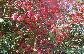
Tham Yai Waterfall is 1.4 kilometers away from Phen Phop Waterfall. There are maples along the way to Tham Yai Waterfall. In the end of November to the early of December, the maple leaves fall and this area become red.
- Than Sawan Waterfall
Than Sawan Waterfall is located in the area of Phu Kradueng National Park. This waterfall is in Nahaew district, Loei. It is a small waterfall which has a height of 15 meters. Than Sawan Waterfall is the nearest waterfall from Amphoe Muang. Moreover, visitors can drive a car to the waterfall.
- Phon Phop Waterfall
Phon Phop Waterfall is a big and beautiful waterfall. The name of the waterfall, Phon Phop, comes from Pone Kingpetch who was the first world champion boxer of Thailand because he found this waterfall when he went to practice boxing and prepared himself for cold weather in a foreign country. Phon Phop Waterfall 558 meters away from Phen Phop Mai Waterfall. This waterfall looks like ladders. The waterfall has 8 levels which has a height of 30 meters.
- Phra Ong Waterfall
Phra Ong Waterfall is located in the area of Phu Kradueng National Park. It comes from Phra Ong canal, which is a small canal, and falls down from the cliff. Phra Ong canal comes from Anodard pond which always has water all year. Phra Ong Waterfall only 4 kilometers away from Wang Kwang Visitor Center.
- Penpobmai Waterfall
Penpobmai Waterfall is a popular waterfall in Phu Kradueng National Park. People love taking photos there because it is rather quaint. Wang Kwang Stream is the origin of another waterfall Phon Phop 8 meters high and 4 kilometers from accommodations. It’s cascade over a sharp rock. In the winter, maples from riverside drop their red leaves to the water’s surface.
- Tat Hong Waterfall
Tat Hong Waterfall is a big waterfall among dense and impenetrable forest. It’s from Namphong Stream and Roi Brook that converged and then its current down. Its height is 70 meters and 80 meters wide. Tat Hong came from current that fall down the rock and makes a rather loud sound. A rainbow is always visible when the sunlight glazed upon the current. It is an ideal place to relax and swim. This place has the way that was used as Seri Thai Freedom Movement to travel from Loei to Petchabun and to allow Field Marshal P. Pibulsongkram to escape Imperialism Japanese army in World War II. In this way also find other interesting spot such as Tat Huai Wua, Hat Sai Khao, Kaeng Hin Tang, Phu Hang (pre-historic color drawings), Phu Lat Mueang viewpoint and Wang Phong Yiam rafting point.
- Wang Kwang Waterfall
Wang Kwang Waterfall is another popular attraction in Loei. It is the closest to the accommodations only 1 kilometer. It is a small waterfall with only 7 meters in height. It looks like a hole down the hill. Close to the forest is a habitat of deers. They go down there to drink water. That is the source of the name Wang Kwang. This area is beautiful in the rain season.
Cliffs Trail
Starting from the visitor center on the mountain, travelers can explore the cliffs trail. There are many cliffs that are known worldwide for their beauty.
- Pha Nok Aen Cliff (ผานกแอ่น) - This cliff is located on the east side of the mountain, approximately 1.1 kilometres from the campsite and tourist office. This is an important tourist spot, where many people go to watch the sunrise. In the summer and rainy season, this cliff is above the clouds, creating a beautiful view of the sunrise.
- Pha Mak Duk Cliff (ผาหมากดูก) - This cliff is located on the south side of the mountain. It is located approximately 2 kilometres from the campsite and tourist office. Travelers who have little time come here to watch the sunset, due to its closeness to the campsite.
- Pha Jam Sin Cliff (ผาจำศีล) - Approximately 600 metres from Pha Mak Duk Cliff.
- Pha Na Noi Cliff (ผานาน้อย) - Approximately 600 metres from Pha Jam Sin Cliff.
- Pha Yiap Mek Cliff (ผาเหยียบเมฆ) - Approximately two kilometres from Pha Na Noi Cliff.
- Pha Daeng Cliff (ผาแดง) - Approximately 1.5 kilometres from Pha Yiap Mek Cliff.
- Pha Lom Sak Cliff (ผาหล่มสัก) - Approximately 2.5 kilometres from Pha Daeng Cliff. This cliff is located on the west side of Phu Kradueng mountain. Most people who climb the mountain will go to watch the sunset at this cliff. On a nice clear day, it's possible to see Phu Pha Jit Mountain (ภูผาจิต) of Nam Nao National Park (อุทยาแห่งชาติน้ำหนาว).
Wild Animals Native to Phu Kradueng
- Deer - Travelers who climb to the top of Phu Kradueng will definitely see at least one deer. One group of deer is looked after in the camp site. This allows these deer to not be scared of humans, thus letting the other deer not be bothered by travelers. The first deer's name is Kam La (คำหล้า) which means "the last born". The second deer's name is Kam Pir (คัมภีร์) which means "religious scripture".
- Leeches - Small bloodsucking invertebrates that are called Thak (ทาก). Leeches are very common to Phu Kradueng beyond the little recognition they receive. Most people don't like them, although they are indigenous to Phu Kradueng's environment. There are a lot of them during the rainy season. They have made residence in many of the building on Phu Kradueng. There are also many near the waterfalls and in the closed forests. They are similar to those found in Khao Yai National Park or Khao Luang National Park, yet are of bigger size.
- Elephants
- Mountain Crabs
Famous Plants and Trees of Phu Kradueng
- Maple Tree or Fai Duean Ha (ไฟเดือนห้า) - The leaves of these trees turn red during the winter season (in Thailand the month of December). If travelers want to be sure that they will see red leaves they can and should phone the park beforehand.
- Nepenthes (a genus of pitcher plants) - Can be found close to the Pha Na Noi and Pha Daeng cliffs.
- Siam Tulip - This tulip can be found close to Pha Yiap Mek and Pha Daeng cliffs. This flower blooms beautifully annually during the month of April. In the month of May you can still find many of these flowers blooming but insects and other animals will have begun to eat them.
References
External links
 Media related to Phu Kradueng National Park at Wikimedia Commons
- Phu Kradueng National Park