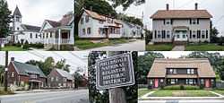
Phillipsdale Historic District
|
Phillipsdale Historic District | |
 | |
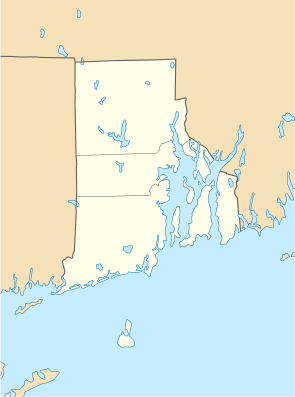 | |
| Location | Roughly bounded by Seekonk River, Roger Williams Ave. & Ruth Ave., East Providence, Rhode Island |
|---|---|
| Coordinates | 41°45′49″N 71°23′27″W / 41.76361°N 71.39083°WCoordinates: 41°45′49″N 71°23′27″W / 41.76361°N 71.39083°W |
| Area | 67 acres (27 ha) |
| Built | 1883 |
| Architect | Multiple |
| Governing body | Local |
| NRHP Reference # | 11000675[1] |
| Added to NRHP | September 15, 2011 |
The Phillipsdale Historic District encompasses a historic mill village along the Seekonk River in East Providence, Rhode Island. The village grew up around the Richmond Paper Company Mill Complex, built 1883-1887, which is separately listed on the National Register. It also includes 75 units of worker housing, as well as five houses (the oldest of which dates to c. 1750) that predate the mill complex's construction. The Phillipsdale area was the largest source of employment in East Providence between 1893 and 1910. The district is centered on Roger Williams Avenue and Bourne Avenue, and includes properties on Ruth Avenue and the grid of roads between Ruth and Roger Williams. It also includes Omega Pond (the historic mill pond).[2]
The district was listed on the National Register of Historic Places in 2011.[1]
See also
References
- ↑ 1.0 1.1 "National Register Information System". National Register of Historic Places. National Park Service. 2009-03-13.
- ↑ "NRHP nomination for Phillipsdale Historic District". Rhode Island Preservation. Retrieved 2014-04-11.
External links
| ||||||||||||||||||||||||||