Phaq'u Q'awa (Sajama)
| Phaq'u Q'awa | |
|---|---|
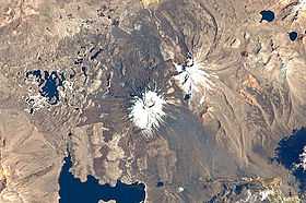 Satellite image showing the Paya Chata mountains and Phaq'u Q'awa north-east of them (upper right corner below the smaller lake, with north to the top right corner) | |
| Elevation | 5,380 m (17,650 ft)[1] |
| Location | |
 Phaq'u Q'awa Location in Bolivia | |
| Location | Bolivia |
| Range | Andes, Cordillera Occidental |
| Coordinates | 18°05′30″S 69°04′08″W / 18.09167°S 69.06889°WCoordinates: 18°05′30″S 69°04′08″W / 18.09167°S 69.06889°W |
Phaq'u Q'awa (Aymara phaq'u, paqu, p'aqu light brown, reddish, blond, dark chestnut, q'awa little river, ditch, crevice, fissure, gap in the earth,[2][3] "brown brook" or "brown ravine", also spelled Paco Khaua, Pacokhaua) is a mountain Cordillera Occidental in the Andes of Bolivia, about 5,380 metres (17,651 ft) high. It is situated in the Oruro Department, Sajama Province, in the west of the Curahuara de Carangas Municipality, north-west of the extinct Sajama volcano. It lies south of the mountain Qullqi Warani.
The river Junt'uma K'uchu (Aymara junt'u warm, hot, uma water, k'uchu corner, "warm water corner", Junthuma Khuchu) originates north of Phaq'u Q'awa. It flows to the south-east as a right affluent of the Sajama River.[1][4]
References
- ↑ 1.0 1.1 Bolivian IGM map 1:50,000 Nevados Payachata Hoja 5739-I
- ↑ Radio San Gabriel, "Instituto Radiofonico de Promoción Aymara" (IRPA) 1993, Republicado por Instituto de las Lenguas y Literaturas Andinas-Amazónicas (ILLLA-A) 2011, Transcripción del Vocabulario de la Lengua Aymara, P. Ludovico Bertonio 1612 (Spanish-Aymara-Aymara-Spanish dictionary)
- ↑ "Diccionario Bilingüe, Castellano - Aymara, Para: Tercera Edición". Félix Layme Pairumani. Retrieved September 15, 2014.
- ↑ "Curahuara de Carangas". Retrieved September 15, 2014.