Peyrilles
| Peyrilles | |
|---|---|
 | |
 Peyrilles | |
|
Location within Midi-Pyrénées region  Peyrilles | |
| Coordinates: 44°37′14″N 1°24′54″E / 44.6206°N 1.415°ECoordinates: 44°37′14″N 1°24′54″E / 44.6206°N 1.415°E | |
| Country | France |
| Region | Midi-Pyrénées |
| Department | Lot |
| Arrondissement | Gourdon |
| Canton | Saint-Germain-du-Bel-Air |
| Intercommunality | Quercy-Bouriane |
| Government | |
| • Mayor (2008–2014) | Stéphane Magot |
| Area1 | 28.41 km2 (10.97 sq mi) |
| Population (2007)2 | 345 |
| • Density | 12/km2 (31/sq mi) |
| INSEE/Postal code | 46219 / 46310 |
| Elevation |
188–384 m (617–1,260 ft) (avg. 259 m or 850 ft) |
|
1 French Land Register data, which excludes lakes, ponds, glaciers > 1 km² (0.386 sq mi or 247 acres) and river estuaries. 2 Population without double counting: residents of multiple communes (e.g., students and military personnel) only counted once. | |
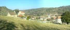
Peyrilles ([peRij] in International Phonetic Alphabet) is a commune in the Lot department in south-western France.
Demographics
People living there are called Peyrillacois.
| Year | 1962 | 1968 | 1975 | 1982 | 1990 | 1999 | 2007 |
|---|---|---|---|---|---|---|---|
| Population | 329 | 369 | 336 | 326 | 340 | 313 | 345 |
| From the year 1962 on: No double counting—residents of multiple communes (e.g. students and military personnel) are counted only once. | |||||||
Places
-
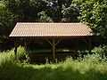
Washing-place of the Dégagnazès
-
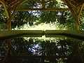
Washing-place Dégagnazès
-
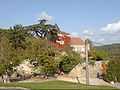
Castel of Peyrilles
-
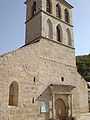
Church of Peyrilles' parish
See also
References
| Wikimedia Commons has media related to Peyrilles. |