Petrokerasa
| Petrokerasa Πετροκέρασα | |
|---|---|
|
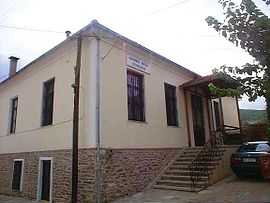
The folklore museum in Petrokerasa | |
 Petrokerasa | |
|
Location within the region | |
| Coordinates: 40°31′N 23°17.1′E / 40.517°N 23.2850°ECoordinates: 40°31′N 23°17.1′E / 40.517°N 23.2850°E | |
| Country | Greece |
| Administrative region | Central Macedonia |
| Regional unit | Thessaloniki |
| Municipality | Langadas |
| Municipal unit | Kallindoia |
| Highest elevation | 530 m (1,740 ft) |
| Lowest elevation | 495 m (1,624 ft) |
| Time zone | EET (UTC+2) |
| • Summer (DST) | EEST (UTC+3) |
| Postal code | 570 12 |
| Area code(s) | +30-2393-xxx-xxx |
| Vehicle registration | NAx-xxxx to NXx-xxxx |
Petrokerasa (Greek: Πετροκέρασα) is a village and a community of the Langadas municipality.[1] Before the 2011 local government reform it was part of the municipality of Kallindoia, of which it was a municipal district.[1] The 2011 census recorded 228 inhabitants in the village.[2] The community of Petrokerasa covers an area of 27.398 km2.[3]
See also
References
- ↑ 1.0 1.1 Kallikratis law Greece Ministry of Interior (Greek)
- ↑
- ↑ Πίνακας 3. Πραγματικός πληθυσμός, επιφάνεια και πυκνότητα του πληθυσμού, με διάκριση σε αστικές και αγροτικές περιοχές καθώς και σε πεδινές, ημιορεινές και ορεινές περιοχές. Μέσος σταθμικός των υψομέτρων. (in Greek). Ελληνική Στατιστική Αρχή (Hellenic Statistical Authority). Retrieved 11 December 2013.
| ||||||||||||||||||||||||||||||