Petra, Boeotia
| Petra Πέτρα | |
|---|---|
|
A view of Petra | |
 Petra | |
|
| |
| Coordinates: 38°22.267′N 23°3.45′E / 38.371117°N 23.05750°ECoordinates: 38°22.267′N 23°3.45′E / 38.371117°N 23.05750°E | |
| Country | Greece |
| Administrative region | Central Greece |
| Regional unit | Boeotia |
| Municipality | Aliartos |
| Municipal unit | Aliartos |
| Highest elevation | 195 m (640 ft) |
| Lowest elevation | 120 m (390 ft) |
| Time zone | EET (UTC+2) |
| • Summer (DST) | EEST (UTC+3) |
| Postal code | 320 01 |
| Area code(s) | +30-2368-xxx-xxx |
| Vehicle registration | ΒΙ |
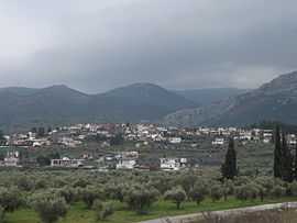
Petra (Greek: Πέτρα) is a village and a community of the Aliartos municipality.[1] Before the 2011 local government reform it was part of the municipality of Aliartos, of which it was a municipal district.[1] The 2011 census recorded 347 inhabitants in the village.[2] The community of Petra covers an area of 24.451 km2.[3]
History
In July 1829, Petra was the site of the Battle of Petra, the last battle of the Greek War of Independence.
See also
References
- ↑ 1.0 1.1 Kallikratis law Greece Ministry of Interior (Greek)
- ↑
- ↑ Πίνακας 3. Πραγματικός πληθυσμός, επιφάνεια και πυκνότητα του πληθυσμού, με διάκριση σε αστικές και αγροτικές περιοχές καθώς και σε πεδινές, ημιορεινές και ορεινές περιοχές. Μέσος σταθμικός των υψομέτρων. (in Greek). Ελληνική Στατιστική Αρχή (Hellenic Statistical Authority). Retrieved 11 December 2013.
| Wikimedia Commons has media related to Petra, Boeotia. |
| ||||||||||