Peters Brook (Stony Brook)
Not to be confused with Peters Brook (Raritan River).
| Peters Brook | |
|---|---|
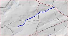 Map of Peters Brook | |
| Origin | 40°22′37″N 74°51′55″W / 40.37694°N 74.86528°W |
| Mouth | 40°23′33″N 74°50′3″W / 40.39250°N 74.83417°W |
| Progression | Stony Brook (Millstone River), Millstone River, Raritan River, Atlantic Ocean |
| Basin countries | United States |
| Mouth elevation | 279 ft (85 m) |
| River system | Raritan River system |
Peters Brook is a tributary of Stony Brook in Mercer County, New Jersey in the United States.[1]
Course
The Peters Brook starts at 40°22′37″N 74°51′55″W / 40.37694°N 74.86528°W,[2] near the intersection of Rock Road East and CR-601 (Mt Airy-Harbourton Road). It flows northeast, crossing Rock Road East and CR-579 (Linvale-Harbourton Road). It flows past the Pine Creek Golf Course before crossing SR-31 and draining into the Stony Brook at 40°23′33″N 74°50′3″W / 40.39250°N 74.83417°W.[2]
Sister tributaries
See also
References
- ↑ USGS Geographic Names Information System (GNIS)
- ↑ 2.0 2.1 "GNIS Detail - Peters Brook". USGS. Retrieved 1 August 2010.