Pest County
| Pest County | |||
|---|---|---|---|
 | |||
| |||
 | |||
| Country | Hungary | ||
| Region | Central Hungary | ||
| County seat | Budapest | ||
| Area | |||
| • Total | 6,393.14 km2 (2,468.41 sq mi) | ||
| Population (2011 census) | |||
| • Total | 1,217,476 | ||
| • Density | 190/km2 (490/sq mi) | ||
| Demonym | Pesti | ||
| ISO 3166 code | HU-P | ||
| Website |
www | ||


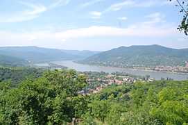
Pest County (Hungarian pronunciation: [pɛʃt]) is a county (megye) in central Hungary. It covers an area of 6,393.14 square kilometres (2,468.41 sq mi), and has a population of 1,213,090 (2009). It surrounds the national capital Budapest and the majority of the county's population (65.2%/790,995 in 2009) live in the suburbs of Budapest. It shares borders with Slovakia and the Hungarian counties Nógrád, Heves, Jász-Nagykun-Szolnok, Bács-Kiskun, Fejér and Komárom-Esztergom. The River Danube flows through the county. The capital of Pest County is Budapest (administratively separate).
History
The present county Pest was formed after World War II, when the former county Pest-Pilis-Solt-Kiskun was split in two parts (the other part is within present-day Bács-Kiskun). Pest County also existed in the early days of the medieval Kingdom of Hungary (11th century). Its territory comprised approximately the north-eastern part of present Pest County. It was combined with adjacent Pilis county before the 15th century. More information can be found at the entry of former Pest-Pilis-Solt-Kiskun county.
Demographics
| Historical population | ||
|---|---|---|
| Year | Pop. | ±% |
| 1870 | 330,089 | — |
| 1880 | 353,851 | +7.2% |
| 1890 | 395,142 | +11.7% |
| 1900 | 450,136 | +13.9% |
| 1910 | 524,320 | +16.5% |
| 1920 | 571,753 | +9.0% |
| 1930 | 633,257 | +10.8% |
| 1941 | 682,696 | +7.8% |
| 1949 | 686,953 | +0.6% |
| 1960 | 781,505 | +13.8% |
| 1970 | 878,644 | +12.4% |
| 1980 | 973,830 | +10.8% |
| 1990 | 949,842 | −2.5% |
| 2001 | 1,083,877 | +14.1% |
| 2011 | 1,217,476 | +12.3% |
Ethnic groups (2001 census):
- Hungarians - 93.5%
- Germans - 1.7%
- Romani - 1.2%
- Slovaks - 0.8%
- Others - 0.5%
- Unknown (no answer) - 2.3%
Religions (2001 census):
- Roman Catholic - 53%
- Calvinist - 16%
- Lutheran - 3.8%
- Greek Catholic - 1.2%
- Others (Christian) - 1.3%
- Others (non-Christian) - 0.2%
- Atheist - 12%
- Unknown (no answer) - 12.5%
Regional structure
City with county's rights
- Érd (65,043) (since 2011)
Towns
(ordered by population, as of 2001)
|
|
|
|
Villages
|
Gallery
-

Halásztelek - Palace
-

Fót - Palace - aerial photo
-
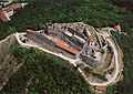
Aerial Photo: Visegrád - Upper Castle
-

Galgahévíz - Szentandráspart
-

Pomáz - Palace
-

Zsámbék - Palece from above
-

Tóalmás - Palace
-

Solymár - Castle
-

The Gödöllő Palace
| ||||||||||||
| ||||||||||||||