Perrecy-les-Forges
| Perrecy-les-Forges | |
|---|---|
|
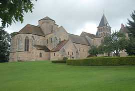
Saint-Pierre and Saint-Benoît church | |
 Perrecy-les-Forges | |
|
Location within Burgundy region  Perrecy-les-Forges | |
| Coordinates: 46°36′56″N 4°12′56″E / 46.6156°N 4.2156°ECoordinates: 46°36′56″N 4°12′56″E / 46.6156°N 4.2156°E | |
| Country | France |
| Region | Burgundy |
| Department | Saône-et-Loire |
| Arrondissement | Charolles |
| Canton | Toulon-sur-Arroux |
| Intercommunality | Creusot-Montceau |
| Government | |
| • Mayor | Claudius Michel |
| Area1 | 33.82 km2 (13.06 sq mi) |
| Population (2006)2 | 1,757 |
| • Density | 52/km2 (130/sq mi) |
| INSEE/Postal code | 71346 / 71420 |
| Elevation |
264–353 m (866–1,158 ft) (avg. 308 m or 1,010 ft) |
|
1 French Land Register data, which excludes lakes, ponds, glaciers > 1 km² (0.386 sq mi or 247 acres) and river estuaries. 2 Population without double counting: residents of multiple communes (e.g., students and military personnel) only counted once. | |
Perrecy-les-Forges is a commune in the Saône-et-Loire department in the region of Bourgogne in eastern France. It played a significant regional influence in the 14th-16th centuries.
The name of the commune indicates that the metallurgic industry has played a role in its economy. A forge from the 17th century,[1] and former coal mines are among the places of interest of the commune.[2]
The church of Perrecy-les-Forges, built during the 12th century, is listed as a Monument historique since 1862 by the French Ministry of Culture.[3]
See also
- Communes of the Saône-et-Loire department
References
| Wikimedia Commons has media related to Perrecy-les-Forges. |