Perivoli, Grevena
| Perivoli Περιβόλι | |
|---|---|
|
Panoramic view of Perivoli from the east | |
 Perivoli | |
|
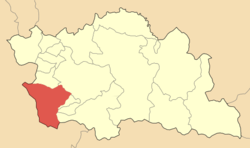
Location within the regional unit  | |
| Coordinates: 39°59′N 21°07′E / 39.983°N 21.117°ECoordinates: 39°59′N 21°07′E / 39.983°N 21.117°E | |
| Country | Greece |
| Administrative region | West Macedonia |
| Regional unit | Grevena |
| Municipality | Grevena |
| • Municipal unit | 137.2 km2 (53.0 sq mi) |
| Population (2011)[1] | |
| • Municipal unit | 21 |
| • Municipal unit density | 0.15/km2 (0.40/sq mi) |
| Time zone | EET (UTC+2) |
| • Summer (DST) | EEST (UTC+3) |
| Postal code | 510 32 |
| Area code(s) | 24620 |
| Vehicle registration | ΡΝ |
Perivoli (Greek: Περιβόλι,Aromanian: Pirivoli) is an alpine village and a former community in Grevena regional unit, West Macedonia, Greece. Since the 2011 local government reform it is part of the municipality Grevena, of which it is a municipal unit.[2] Its population was 21 inhabitants as of 2011.[1] It was the least densely populated municipality or community in the least densely populated regional unit of Greece. It is also the sixth-least densely populated in all of Greece (behind Gramos, Sidironero, Paranesti, Antikythira, and Gavdos). The village is inhabited during winter by only 10-20 people due to extreme snow. However, the population rises to 4,000 people during the summer. There are many restored houses, inns, restaurants and cafes in the village. The inhabitants are mainly native Aromanians (Greek: Βλάχοι).
Geography
It is situated at an altitude of 1250–1370 meters in the southwest corner of Grevena regional unit in southwestern Greek Macedonia. The community has a land area of 137.210 km² and consists solely of one village, Perivóli. The southernmost portion of the community is part of the Pindos National Park.
References
- ↑ 1.0 1.1 "Detailed census results 2011" (in Greek).
- ↑ Kallikratis law Greece Ministry of Interior (Greek)
External links
- Pindos National Park
- Official website (Greek)
| ||||||||||||||||||||||||||||||||||||||||||||||||||||||