Periglaciation

Periglaciation (adjective: "periglacial," also referring to places at the edges of glacial areas) describes geomorphic processes that result from seasonal thawing of snow in areas of permafrost, the runoff from which refreezes in ice wedges and other structures. [1][2] Tundra is a common ecological community in periglacial areas.
Extent of periglaciation
Some earth scientists have likened the extent of periglaciation to that of permafrost. Under this definition large areas in Siberia, Canada and Alaska and smaller areas in Fennoscandia, Tibet, Iceland, Greenland, Antarctica and the Andes are periglaciated. Not all scientists agree with this definition as many areas without permafrost show significant action of processes related to the freezing of water.
Periglaciation occurs principally in areas of permafrost. These areas experience intense freezing with an active layer of freeze/thaw near the surface which thaws briefly in summer. Periglaciation occurs near mountain glaciers. At lower levels it forms a zone of cold around continental glaciers in areas of high latitudes, covering perhaps 20% of the earth’s land surface.
Periglacial conditions in the Pleistocene created landscapes and geological conditions moulded by frost action; the repeated freezing and thawing of material over many years. Around a third of the Earth's land surface can be considered as having been subject to periglacial conditions at some time.
Factors affecting location
- Latitude – temperatures tend to be higher towards the equator. Periglacial environments tend to be found in higher latitudes. Since there is more land at these latitudes in the north, most of this effect is seen in the northern hemisphere. However, in lower latitudes, the direct effect of the sun's radiation is greater so the freeze-thaw effect is seen but permafrost is much less widespread.
- Altitude – Air temperature drops by approximately 1 °C for every 100 m rise above sea level. This means that on mountain ranges, modern periglacial conditions are found nearer the Equator than they are lower down.
- Ocean Currents – Cold surface currents from polar regions, reduce mean average temperatures in places where they exert their effect so that ice caps and periglacial conditions will show nearer to the Equator as in Labrador for example. Conversely, warm surface currents from tropical seas increases mean temperatures. The cold conditions are then found only in more northerly places. This is apparent in western North America which is affected by the North Pacific current. In the same way but more markedly, the Gulf Stream affects Western Europe.
- Continentality – Away from the moderating influence of the ocean, seasonal temperature variation is more extreme and freeze-thaw goes deeper. In the centres of Canada and Siberia, the permafrost typical of periglaciation goes deeper and extends further towards the Equator. Similarly, solifluction associated with freeze-thaw extends into somewhat lower latitudes than on western coasts.
Landforms of periglaciation
Periglaciation results in a variety of ground conditions but especially those involving irregular, mixed deposits created by ice wedges, solifluction, gelifluction, frost creep and rockfalls. Periglacial environments trend towards stable geomorphologies.[3]
- Coombe and head deposits – Coombe deposits are chalk deposits found below chalk escarpments in Southern England. Head deposits are more common below outcrops of granite on Dartmoor.
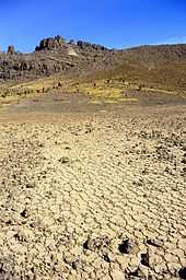
- Patterned Ground – Patterned ground occurs where stones form circles, polygons and stripes. Local topography affects which of these are expressed. A process called frost heaving is responsible for these features.
- Periglacial lakes – Periglacial lakes are formed where the natural drainage of the topography is obstructed by an ice sheet, ice cap or glacier. Periglacial lakes are not typical of areas under the modern periglacial definition, since most of them formed temporarily during the last deglaciation and are not necessarily associated to landforms created by the freezing of water (glaciers not accounted).
- Solifluction lobes – Solifluction lobes are formed when waterlogged soil slips down a slope due to gravity forming U shaped lobes.
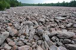
- Blockfields or Felsenmeer – Blockfields are areas covered by large angular blocks, traditionally believed to have been created by freeze-thaw action. A good example of a blockfield can be found in the Snowdonia National Park, Wales. Blockfields are common in the unglaciated parts of the Appalachian Mountains in the northeastern United States, such as at the River of Rocks or Hickory Run Boulder Field, Lehigh County, Pennsylvania.
Other landforms include:
River activity
Most areas under periglaciation have relatively low precipitation (if not the areas would likely be glaciated) and low evapotranspiration. which makes average river discharge rates low. Many rivers flowing into the Arctic sea of northern Canada and Siberia have despite this a very strong erosive capacity due to the fact that thaw occurs first in the upper part of the drainage basin leading to large areas being flooded further down (north) because of obstructing river ice. When these dams melt or break large amounts of water are released with destructive and erosive power.
Chemical and physical weathering
Despite ordinary beliefs there is no predominance of physical weathering over chemical weathering in periglacial areas, however the action of physical weathering is relatively more important if compared to weathering activity in warmer areas.
References
- ↑ Murck, Barbara (2001). Geology; A Self-teaching Guide. New York, New York: John Wiley & Sons, Inc. ISBN 0-471-38590-5.
- ↑ Slaymaker O., 2011. Criteria to distinguish between periglacial, proglacial and paraglacial environments. Quaestiones Geographicae 30(1): 85–94. DOI 10.2478/v10117-011-0008-y.
- ↑ Brundsen, D. A critical assessment of the sensitivity concept in geomorphology. 2001. Catena vol. 42.
| Look up periglaciation in Wiktionary, the free dictionary. |
| ||||||||||||||||||||||||