Percy Priest Lake
| Percy Priest Lake | |
|---|---|
 | |
| Location | Davidson / Rutherford / Wilson counties Tennessee, US |
| Coordinates | 36°09′25″N 86°37′03″W / 36.15694°N 86.61750°WCoordinates: 36°09′25″N 86°37′03″W / 36.15694°N 86.61750°W |
| Type | reservoir |
| Primary inflows | Stones River |
| Primary outflows | Stones River |
| Basin countries | United States |
| Surface area | 14,200 acres (5,700 ha) |
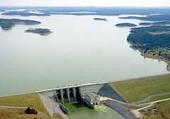
J. Percy Priest Lake is a reservoir in north central part of Tennessee. It is formed by J. Percy Priest Dam, located between miles six and seven of the Stones River. The dam (easily visible from Interstate 40) is located about 10 miles (16 km) east of downtown Nashville and impounds a lake 42 miles (68 km) long. The lake and dam are named for Congressman Percy Priest.
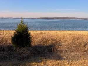
The lake covers portions of Davidson, Rutherford and Wilson counties and consists of 14,200 acres (57 km²) of water at summer pool elevation 490 feet (149 m) above mean sea level. The water is surrounded by 18,854 acres (76 km²) of public lands; 10,000 acres (40 km²) are devoted to wildlife management. The site of the former town of Old Jefferson was inundated by the reservoir; the community was demolished in the early 1960s for the building of the dam.[1]
The Percy Priest dam project was first authorized by the U.S. Congress in 1946 under the name “Stewarts Ferry Reservoir.” An act of Congress approved July 2, 1958, changed the name to honor Congressman Priest. The U.S. Army Corps of Engineers project was completed in 1967.[2]
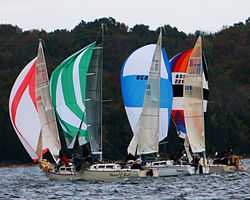
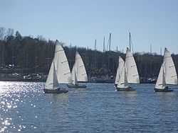
The dam, powerhouse, lake and public lands are operated and supervised by the Corps of Engineers' Nashville District personnel. The Natural Resource Management Office maintains three campgrounds (Anderson Road, Seven Points and Poole Knobs), eleven day-use/picnic areas (Anderson Road, Cook, Damsite, East Fork, Fate Sanders, Jefferson Springs, Nice's Mill, Overlook, Seven Points, Smith Springs and Tailwater) and twelve boat launching ramps (Anderson Road, Cook, East Fork, Fall Creek, Fate Sanders, Hurricane Creek, Jefferson Springs, Lamar Hill, Mona, Nice's Mill, Poole Knobs, Seven Points, Smith Springs, Stewart's Creek and Viverett Creek). Marinas at the lake include Nashville Shores, Elm Hill, Four Corners, Fate Sanders, Hamilton Creek and Percy Priest. The lake is also home to a number of recreational organizations such as the Tennessee Boat Club, Percy Priest Yacht Club, Vanderbilt Sailing Club, the Vanderbilt Rowing Club and the Nashville Rowing Club.
Boat Clubs
Tennessee Boat Club - Bell Road Hermitage, TN 37076 (615) 601-2582 - http://www.tennesseeboatclub.com/
Percy Priest Yacht Club - P.O. Box 150642 Nashville, TN 37215 http://www.ppyc.org/
Marinas
Nashvillle Shores Marina (owned and operated by Premier Parks, LLC) 4001 Bell Road Hermitage, Tennessee 37076 (615) 883-0413 www.nashvilleshores.com
Elm Hill Marina 3361 Bell Road Nashville, Tennessee 37214 (615) 889-5363 www.elmhillmarina.com
Hamilton Creek Sailboat Marina 2901 Bell Road Nashville, Tennessee 37214 (615) 862-8472 www.nashville.gov/parks/marina.asp
Four Corners Marina 4027 Lavergne-Couchville Pike Antioch, Tennessee 37013 (615) 641-9523 www.fourcornersmarina.com
Fate Sanders Marina 3157 Weakly Lane Smyrna, Tennessee 37167 (615) 459-6219 www.fatesandersmarina.net
References
- ↑ Old Jefferson, Rutherford County, Tennessee, Genealogy website
- ↑ Dates in Nashville District History, U.S. Army Corps of Engineers Nashville District website, accessed August 11, 2009
Images