Pentagon City Station
Pentagon City | ||||||||||||||||
|---|---|---|---|---|---|---|---|---|---|---|---|---|---|---|---|---|
| Washington Metro rapid transit station | ||||||||||||||||
 | ||||||||||||||||
| Location |
1250 South Hayes Street Arlington, VA 22202 | |||||||||||||||
| Coordinates | 38°51′46″N 77°03′34″W / 38.86271°N 77.059468°WCoordinates: 38°51′46″N 77°03′34″W / 38.86271°N 77.059468°W | |||||||||||||||
| Owned by | WMATA | |||||||||||||||
| Line(s) |
| |||||||||||||||
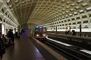
| Platforms | 2 side platforms | |||||||||||||||
| Tracks | 2 | |||||||||||||||
| Connections |
| |||||||||||||||
| Construction | ||||||||||||||||
| Structure type | Underground | |||||||||||||||
| Bicycle facilities | 8 racks, 22 lockers | |||||||||||||||
| Disabled access | Yes | |||||||||||||||
| Other information | ||||||||||||||||
| Station code | C08 | |||||||||||||||
| History | ||||||||||||||||
| Opened | July 1, 1977 | |||||||||||||||
| Traffic | ||||||||||||||||
| Passengers (2007) |
9.936 million[1] | |||||||||||||||
| Services | ||||||||||||||||
| ||||||||||||||||
Pentagon City is a side platformed Washington Metro station in the Pentagon City neighborhood of Arlington, Virginia, United States. The station was opened on July 1, 1977, and is operated by the Washington Metropolitan Area Transit Authority (WMATA). Providing service for both the Blue and Yellow Lines, the station is located at the corner of Hayes Street and 12th Street, between Army-Navy Drive and South 15th Street. It links to a tunnel that allows direct access west into the Fashion Centre at Pentagon City, a large shopping mall, and east under Hayes Street to an entrance outside the Pentagon Centre shopping complex.
The station opened on July 1, 1977.[2] Its opening coincided with the completion of 11.8 miles (19.0 km)[3] of rail between National Airport and RFK Stadium and the opening of the Arlington Cemetery, Capitol South, Crystal City, Eastern Market, Farragut West, Federal Center SW, Federal Triangle, Foggy Bottom–GWU, L'Enfant Plaza, McPherson Square, National Airport, Pentagon, Potomac Avenue, Rosslyn, Smithsonian and Stadium–Armory stations.[4]
A provision exists at the station's south end for a future second mezzanine, with knock-out panels visible above the tracks on the station's south wall. Additionally, an abandoned pedestrian tunnel exists beyond a set of glass doors off the station mezzanine, which leads to the northeast side of the intersection of 12th and Hayes Streets.[5] According to Arlington County Commuter Services, this tunnel is to be refurbished and opened to the public.[6]
Station layout
| G | Street Level | Exit/ Entrance |
| M | Mezzanine | One-way faregates, ticket machines, station agent |
| P Platform level |
Side platform, doors will open on the right | |
| Westbound | ← ← | |
| Eastbound | → → | |
| Side platform, doors will open on the right | ||
References
- ↑ FY2006-07 Metrorail ridership summary by station Think Outside the Car Retrieved 2009-11-28
- ↑ Feaver, Douglas B. (July 1, 1977), "Today, Metro could be U.S. model", The Washington Post: A1
- ↑ Washington Metropolitan Area Transit Authority (July 2009). "Sequence of Metrorail openings" (PDF). Retrieved July 25, 2010.
- ↑ Staff Reporters (June 24, 1977), "Metro's newest stations: Where they are, what's nearby", The Washington Post
- ↑ "Abandoned Tunnel at Pentagon City". The Schumin Web Transit Center. Retrieved 2006-10-01.
- ↑ "Pentagon City Pedestrian Tunnel Repair Project". Retrieved 2008-10-20.
External links
![]() Media related to Pentagon City (WMATA station) at Wikimedia Commons
Media related to Pentagon City (WMATA station) at Wikimedia Commons
- WMATA: Pentagon City Station
- StationMasters Online: Pentagon City Station
- The Schumin Web Transit Center: Pentagon City Station
- 12th Street entrance from Google Maps Street View