Penrhyn (atoll)
| Native name: <span class="nickname" ">Tongareva | |
|---|---|
|
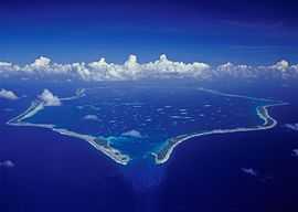
Aerial view of Penrhyn. | |
| Geography | |
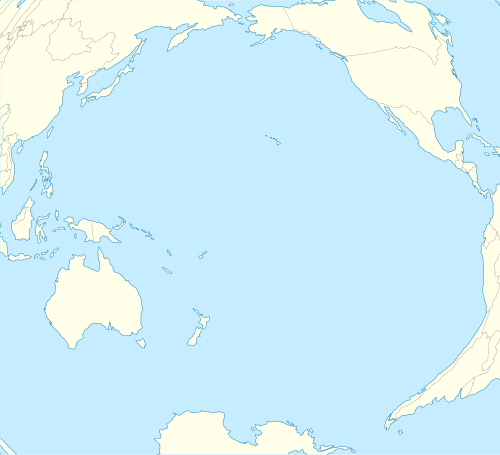
| Location | Central-Southern Pacific Ocean |
| Coordinates | 9°00′20″S 157°58′10″W / 9.00556°S 157.96944°W |
| Area | 9.8 km2 (3.8 sq mi) |
| Country | |
Penrhyn (also called Tongareva, Mangarongaro, Hararanga, and Te Pitaka) is the most remote and largest atoll of the 15 Cook Islands in the south Pacific Ocean.
Geography
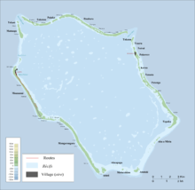
Located at 1,365 km (848 mi) north-north-east of Rarotonga, 9 degrees south of the equator. It sits atop the highest submarine volcano in the Cooks, 4876 m (15,917 ft) above the ocean floor. It is composed of a ring of coral 77 km (48 mi) around. The lagoon covers 233 square kilometres (90 mile²) of which 62 square kilometres (24 mile²) is covered with pearlshell.[1][2] Land area is 9.84 square kilometres (2,432 acres). Maximum elevation less than 5 m. Population according to the 2001 census was 351 with a decrease by 2011 to only 213 inhabitants.[3]
People & culture
Villages
Penrhyn Atoll has two villages. The main village of Omoka, seat of Penrhyn Island Council, is on Moananui Islet, on the western rim of the atoll, north of the airport. The village of Te Tautua is on Pokerere Islet, on the eastern rim.
The religion of the inhabitants of the island is divided, 75% of the population belong to the Cook Islands Christian Church while the remaining 25% belong to the Roman Catholic Church.
History

Etymology
Penrhyn's original name is Tongareva. Academic research published by the Cook Islands Library and Museum says this is variously translated as "Tonga floating in space", "Tonga-in-the-skies" and "A way from the South". However, the most commonly used name in English is Penrhyn after the Lady Penrhyn commanded by Captain William Cropton Sever, who landed on 8 August 1788. Another European name was Bennett Island.[4] The Lady Penrhyn was one of a fleet of 11 ships which sailed from the Isle of Wight (off the south coast of the UK) to found the earliest convict colony in Australia
Slavery
In 1864, Penrhyn was almost depopulated by Peruvian expeditions. An estimated 1,000 men, women and children were taken to South America. Native pastors of the London Missionary Society had introduced Christianity from Rarotonga in 1854. The new religion had been accepted enthusiastically, and the villagers immediately started to build churches. Promises from the slavers of good pay and safe return offered a way to obtain money for churches, but most who accepted died in exile, virtually slaves.[5] Another source states that, in 1863, 410 inhabitants of the total population of about 500 were kidnapped by blackbirding by the Peruvian blackbirders who were assisted by four native missionary teachers, who sold their people for 5 dollars per head. The missionaries accompanied the slaves to Peru as their interpreters. [6]
Foreign claims
The Cook Islands were a British protectorate 1888 to 1900, when annexed to New Zealand, until independence in 1965 when residents chose self-government in free association with New Zealand.[7]
From 1856 to 1980, the United States claimed sovereignty over the island under the Guano Islands Act. That claim had never been recognized by Britain, New Zealand or the Cook Islands and New Zealand sovereignty was recognized during World War II U.S. military operations involving the islands. On 11 June 1980, in connection with establishing the maritime boundary between the Cook Islands and American Samoa, the U.S. signed a treaty with the Cook Islands in which it acknowledged that the island was under Cook Islands sovereignty.[8][9]
World War II
In early 1942 Japanese advances had placed the South Pacific air ferry route's initial path at some risk so that an alternate route was directed. In March Leif J. Sverdrup determined on a tour of potential island sites that Penrhyn was suitable and, though all land was owned by the local population and it was illegal to sell, use could be arranged and local labor could help build an airfield. Work on the airfield began in July 1942 with aviation gasoline storage tanks added to the completed field.[8] A communications link through the island was established by the U.S. Army Signal Corps.[10] The Army vessel Southern Seas struck an uncharted reef 22 July 1942 and was severely damaged with flooded engine rooms and abandoned in Taruia Pass while on an island charting assignment in support of the construction. The ship was later salvaged by the Navy and commissioned for naval use.[11][12]
Economy & resources

The World War II airstrip is still used today although flights to the atoll are not regular.
A large passage in the lagoon allows inter-island ships to enter the lagoon, and the island has become popular as a stopover for yachts crossing the Pacific from Panama to New Zealand. The inter-island Taio shipping company visits the island approximately every three months.
The locally produced Rito hats, woven from coconut fibre, are considered the finest in the whole South Pacific. The fibre is from young coconut leaves which are stripped, boiled and dried resulting in a fine white leaf. Called rito weaving, the traditional items woven are Sunday church fans, small baskets and hats, the hats being a copy of the ones the sailors wore.[13]
Black pearl farming
Black pearl farming is the only significant economic activity on the island.[14]
Food
The present population of the island rely on the ocean for most of their food as well as locally grown plants such as coconut and breadfruit. Every morning (except on Sundays) men from the island head out in small tin boats to spear or trawl for fish for their families. The islanders' diet is supplemented by imported rice and flour shipped in from Rarotonga. The boats are infrequent (usually every 3 months); however, the boat is often late and the people of Penrhyn are forced to make do with what food they can provide for themselves.
See also
References
- ↑ Tongareva - The Island Floating in Space
- ↑ Penrhyn, Cook Islands
- ↑ "Cook Islands". City Population—Population Statistics for Countries, Administrative Areas, Cities and Agglomerations. Retrieved 29 August 2013.
- ↑ Kloosterman, Alphons M. J. (1976). "Discoverers Of The Cook Islands And The Names They Gave". Cook Islands Library and Museum (web: Victoria University of Wellington). Retrieved 29 August 2013.
- ↑ Tongareva Island
- ↑ Tongareva (Penrhyn) Atoll – Cook Islands – Northern Group, South
- ↑ Central Intelligence Agency (13 August 2013). "Cook Islands, World Factbook".
- ↑ 8.0 8.1 Dod, Karl C. (1987). The Corps Of Engineers: The War Against Japan. United States Army In World War II. Washington, DC: Center Of Military History, United States Army. pp. 169,171,233. LCCN 66060004.
- ↑ Office of The Geographer, Bureau of Intelligence and Research (2013). "Limits In The Seas No. 100; Maritime Boundaries: United States—Cook Islands and United States—New Zealand (Tokelau)" (PDF). Retrieved 29 August 2013.
- ↑ Thompson, George Raynor; Harris, Dixie R.; Oakes, Pauline M.; Terrett, Dulany (1957). The Technical Services—The Signal Corps: The Test (December 1941 to July 1943). United States Army In World War II. Washington, DC: Center Of Military History, United States Army. pp. 475–476. LCCN 56060003.
- ↑ "Section 3 – Publications, US Army Corps of Engineers" (PDF). U.S. Army Engineers in Hawaii. Retrieved 17 June 2013.
- ↑ "Southern Seas". Dictionary of American Naval Fighting Ships. Naval History & Heritage Command. Retrieved 17 June 2013.
- ↑ Mahina Expedition – Offshore Cruising Instruction
- ↑ Cook Islands Government Online: Pearls
External links
| Wikimedia Commons has media related to Penrhyn Island. |
- Map of Penrhyn
- Photos and information about Penrhyn
- Tongareva Island info
- Older map, but with more details
Coordinates: 9°00′20″S 157°58′10″W / 9.00556°S 157.96944°W
| ||||||||||||||||