Pennsylvania Route 902
| ||||
|---|---|---|---|---|
 | ||||
| Route information | ||||
| Maintained by PennDOT | ||||
| Length: | 11.662 mi[1] (18.768 km) | |||
| Major junctions | ||||
| West end: |
| |||
| East end: |
| |||
| Location | ||||
| Counties: | Carbon | |||
| Highway system | ||||
| ||||

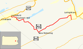
Pennsylvania Route 902 (PA 902) is an 11.66-mile-long (18.76 km) east–west state highway in the US state of Pennsylvania, and serves to connect the boroughs of Lansford and Lehighton in Carbon County. The route was first signed in 1928. The eastern terminus was originally at the intersection of Mill Road and Mahoning Drive West in Mahoning Township. In 1940, the route was extended to its current length.[2]
Route description
PA 902 begins as Spring Garden Street in Lansford at the intersection with US 209. It then enters Summit Hill and becomes North Street. It travels north/south for several blocks in Summit Hill signed as Pine Street. It then carries the name Laurel Street to the border of Summit Hill and Mahoning Township, where it becomes Mill Road. PA 902 turns onto Mahoning Drive West at New Mahoning and continues to Lehighton, where it becomes Mahoning Street. It then turns onto Ninth Street where it continues to its eastern terminus at PA 443 in Lehighton.[3]
Major intersections
The entire route is in Carbon County.
| Location | mi[1] | km | Destinations | Notes | |
|---|---|---|---|---|---|
| Lansford | 0.000 | 0.000 | |||
| Lehighton | 11.662 | 18.768 | |||
| 1.000 mi = 1.609 km; 1.000 km = 0.621 mi | |||||
See also
- U.S. Roads portal
- Pennsylvania portal
References
Route map: Bing
- ↑ 1.0 1.1 Bureau of Maintenance and Operations (December 31, 2012). "Roadway Management System Straight Line Diagrams" (2013 ed.). Pennsylvania Department of Transportation. Retrieved September 14, 2013.
- Carbon County (PDF)
- ↑ Pennsylvania Highways- Pennsylvania Route 902
- ↑ Google (April 21, 2013). "Pennsylvania Route 902" (Map). Google Maps. Google. Retrieved April 21, 2013.