Pennsylvania Route 895
| ||||
|---|---|---|---|---|
 | ||||
| Route information | ||||
| Maintained by PennDOT | ||||
| Length: | 47.19 mi[1] (75.94 km) | |||
| Major junctions | ||||
| West end: |
| |||
| East end: |
| |||
| Location | ||||
| Counties: | Schuylkill, Carbon | |||
| Highway system | ||||
| ||||

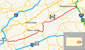
Pennsylvania Route 895 (PA 895) is a 47.19 mi (75.94 km) state highway in the U.S. state of Pennsylvania. It is designated as an east–west route, with termini at Route 443 in Pine Grove[2] and Route 248 in Bowmanstown.[3] The entire course is close to the north flank of Blue Mountain.
Route description
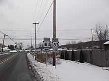
PA 895 begins at an intersection with Route 443 in Pine Grove. A little west of that point on 443, it is a termination point for Route 501.[2] From there, it starts heading east for 10 miles until it reaches Route 183.[4]
After that, the route starts heading northeast and follows the left bank of Bear Creek, passing through Auburn along the way. The Schuylkill County Fairgrounds is on the right side approximately 1 1/2 miles east of 183. While exiting Auburn, 895 crosses the Schuylkill River and continues to Route 61 in Deer Lake. It turns right on 61 south to Molino, where it turns left northward following the Little Schuylkill River to McKeansburg, where it joins Route 443.
443 and 895 depart in New Ringgold, where 443 turns north and 895 continues east and crosses to the Lehigh watershed in West Penn Township. It follows the Lizard Creek and intersects Route 309 in Snyders. The boundary with Carbon County is just beyond Andreas (locally pronounced "ANN-dreez.")
895 continues its eastward course through the Lizard Valley across East Penn Township. It passes through the village of Ashfield, and immediately after crossing the Lehigh River, interchanges with the 248 expressway at its eastern terminus in Bowmanstown.
Major intersections
| County | Location | mi[1] | km | Destinations | Notes |
|---|---|---|---|---|---|
| Schuylkill | Pine Grove | 0.00 | 0.00 | ||
| Pine Grove Township | 0.60 | 0.97 | Northern terminus of PA 501 | ||
| Wayne Township | 10.16 | 16.35 | |||
| Deer Lake | 19.24 | 30.96 | West end of PA 61 concurrency | ||
| North Manheim Township | 20.83 | 33.52 | East end of PA 61 concurrency | ||
| East Brunswick Township | 26.28 | 42.29 | West end of PA 443 concurrency | ||
| New Ringgold | 27.62 | 44.45 | East end of PA 443 concurrency | ||
| West Penn Township | 35.66 | 57.39 | |||
| Carbon | Bowmanstown | 47.19 | 75.94 | Interchange | |
1.000 mi = 1.609 km; 1.000 km = 0.621 mi
| |||||
See also
- U.S. Roads portal
- Pennsylvania portal
References
- ↑ 1.0 1.1 DeLorme Street Atlas USA 2007 software, Toggle Measure Tool. Retrieved on 2007-07-27.
- ↑ 2.0 2.1 Google (2007-07-27). "Western terminus" (Map). Google Maps. Google. Retrieved 2007-07-27.
- ↑ Google (2007-07-27). "Eastern terminus" (Map). Google Maps. Google. Retrieved 2007-07-27.
- ↑ Google (2007-07-29). "PA 895 at 183" (Map). Google Maps. Google. Retrieved 2007-07-29.
External links
Route map: Bing
| Wikimedia Commons has media related to Pennsylvania Route 895. |