Pennsylvania Route 670
| ||||
|---|---|---|---|---|
 | ||||
| Route information | ||||
| Maintained by PennDOT | ||||
| Length: | 21.36 mi[1] (34.38 km) | |||
| Major junctions | ||||
| South end: |
| |||
|
| ||||
| North end: |
| |||
| Location | ||||
| Counties: | Wayne | |||
| Highway system | ||||
| ||||

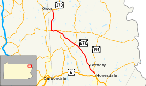
Pennsylvania Route 670 (also known by the Pennsylvania Department of Transportation as SR 670) is a 21.36-mile-long (34.38 km) state highway located in Wayne County, Pennsylvania. The southern terminus is at Route 191 in Honesdale. The northern terminus is at Route 370 in Preston Township.
Route description
PA 670 begins at an intersection with PA 191 in Honesdale, heading northwest on two-lane undivided Elm Place. The road heads through wooded areas with some homes, crossing into Dyberry Township. Here, the route becomes Bethany Turnpike and continues through more wooded areas with some fields and residences, turning north. PA 670 enters Bethany, where it becomes Wayne Street and passes homes, turning northwest. The road heads back into Dyberry Township and becomes Bethany Turnpike again, heading north through woodland with some fields and residences. The route turns northwest and runs through more rural areas, crossing into Mount Pleasant Township and coming to an intersection with PA 247. PA 670 runs through more farmland and woodland with homes, passing through Whites Valley and intersecting the northern terminus of PA 170. The road continues northwest to an intersection with PA 371 in Pleasant Mount. At this point, PA 670 turns west to form a concurrency with PA 371 on Great Bend Turnpike, heading west through more rural areas. In Belmont Corner, PA 670 splits from PA 371 by turning north onto Belmont Turnpike, running through more farms and woods with residences. PA 670 continues northeast and north through more rural areas, entering Preston Township and ending at an intersection with PA 370 in Orson.[2][3]
Major intersections
The entire route is in Wayne County.
| Location | mi | km | Destinations | Notes | |
|---|---|---|---|---|---|
| Honesdale | 0.00 | 0.00 | |||
| Mount Pleasant Township | 9.10 | 14.65 | |||
| 13.59 | 21.87 | Northern terminus of Route 170 | |||
| 14.91 | 24.00 | Southern end of concurrency with Route 371 | |||
| 16.08 | 25.88 | Northern end of concurrency with Route 371 | |||
| Preston Township | 21.36 | 34.38 | |||
1.000 mi = 1.609 km; 1.000 km = 0.621 mi
| |||||
See also
- U.S. Roads portal
- Pennsylvania portal
References
- ↑ Yahoo!; Navteq (February 9, 2011). "Overview map of Pennsylvania Route 670" (Map). Yahoo! Maps. Yahoo!. Retrieved February 9, 2011.
- ↑ Google (December 7, 2011). "overview of Pennsylvania Route 670" (Map). Google Maps. Google. Retrieved December 7, 2011.
- ↑ Wayne County, Pennsylvania Highway Map (PDF) (Map). PennDOT. 2011. Retrieved December 7, 2011.
External links
Route map: Bing
- Kitsko, Jeffrey J. (2011). "PA 670". Pennsylvania Highways. pp. 651–700.