Pennsylvania Route 516
| ||||
|---|---|---|---|---|
 | ||||
| Route information | ||||
| Maintained by PennDOT | ||||
| Length: | 12.461 mi[1] (20.054 km) | |||
| Major junctions | ||||
| South end: |
| |||
|
| ||||
| North end: |
| |||
| Location | ||||
| Counties: | York | |||
| Highway system | ||||
| ||||

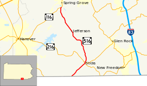
Pennsylvania Route 516 (PA 516) is a 12.5-mile-long (20.1 km) state highway located in York County, Pennsylvania. The southern terminus is the Maryland state line in Manheim Township. The northern terminus is at PA 116 in Spring Grove.
Route description
PA 516 begins at the Maryland border in Manheim Township, heading to the northeast on two-lane undivided Lineboro Road. The road continues into Maryland as MD 86. From the state line, the route runs through open agricultural areas in a narrow valley with a few homes. PA 516 crosses into Codorus Township and reaches the community of Sticks, intersecting the western terminus of PA 851. Here, the route turns north onto Steltz Road and crosses PA 216 a short distance later, becoming Jefferson Road at this point. The road continues north through wooded areas with some homes before heading back into agricultural surroundings with occasional patches of woods and residences. The route turns more to the northwest and continues into Jefferson, where it becomes Baltimore Street and passes homes. Upon reaching a roundabout with Hanover Street/York Street in the center of town, PA 516 becomes Berlin Street. Upon leaving Jefferson, the route enters North Codorus Township and becomes Jefferson Road again and passes through a mix of farmland and residences. Farther to the north, PA 516 reaches its northern terminus at an intersection with PA 116 to the south of Spring Grove.[2][3]
Major intersections
The entire route is in York County.
| Location | mi[1] | km | Destinations | Notes | |
|---|---|---|---|---|---|
| Manheim Township | 0.000 | 0.000 | Maryland state line | ||
| Codorus Township | 2.760 | 4.442 | Western terminus of PA 851 | ||
| 2.860 | 4.603 | ||||
| North Codorus Township | 12.461 | 20.054 | |||
| 1.000 mi = 1.609 km; 1.000 km = 0.621 mi | |||||
See also
- U.S. Roads portal
- Pennsylvania portal
References
Route map: Bing
- ↑ 1.0 1.1 "Pennsylvania state roads". Pennsylvania Spatial Data Access. Pennsylvania Department of Transportation. 2013. Retrieved March 14, 2013.
- ↑ Google (February 24, 2011). "overview of Pennsylvania Route 516" (Map). Google Maps. Google. Retrieved February 24, 2011.
- ↑ York County, Pennsylvania Highway Map (PDF) (Map). PennDOT. 2011. Retrieved February 22, 2011.