Pennsylvania Route 423
| ||||
|---|---|---|---|---|
 | ||||
| Route information | ||||
| Maintained by PennDOT | ||||
| Length: | 14.45 mi[1] (23.26 km) | |||
| Existed: | 1965 – present | |||
| Major junctions | ||||
| South end: |
| |||
|
| ||||
| North end: |
| |||
| Location | ||||
| Counties: | Monroe, Wayne | |||
| Highway system | ||||
| ||||

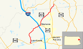
Pennsylvania Route 423 (designated by the Pennsylvania Department of Transportation as SR 0423) is a state route in Monroe and Wayne Counties in Pennsylvania. It runs for 14.45 miles (23.26 km), crossing through the Pocono Mountains from Route 940 in Pocono Pines to Route 191 in South Sterling.
Route 423 was established in 1965. From 1925 to 1965 it was designated as Route 490, a spur of the former Route 90 (now Route 191).
Route description
Route 423 begins at an intersection with Route 940 in the community of Pocono Pines. The route heads northbound as Warnertown Road, progressing around the shores of Lake Naomi. The surroundings of the highway are primarily residential. Just after the intersection with Firehouse Road in Pocono Pines, the road turns eastward along the westernmost shore of Lake Naomi. After Route 423 leaves the shoreline, it turns northward and continues through the residential hills north of the lake. The highway passes through a small community named Lake Naomi Estates. It soon passes a local school and leaves Lake Naomi Estates. The surroundings become woodlands as Route 423 darts northwest and soon to the northeast. The two-lane highway maintains the northeast progression through forests until turning north and crossing a creek. There it turns eastward and returns northeastward for several miles and after several changes enters the community of Warnertown. Just after crossing the small community, Route 423 enters an interchange with Interstate 380.[2]

After crossing the interchange with Interstate 380, Route 423 heads eastward and enters an at-grade intersection with Route 611 in Tobyhanna. The road is renamed to Prospect Street and enters downtown Tobyhanna, crossing through a residential stretch. At Main Street, Prospect Street ends and Route 423 turns northward onto Main Street. This does not last, as the designation darts northward on Church Street. Following Church Street out of downtown Tobyhanna, Route 423 crosses the former main line of the Delaware, Lackawanna and Western Railroad, passing the former Tobyhanna Station and interlocking tower for the switch to the Tobyhanna Army Depot. The highway continues north of the tracks and along the side of the Army Depot into a rural portion of Tobyhanna. The name changes from Church Street to Tobyhanna State Park Road, entering the namesake park near Tobyhanna Lake. Route 423 passes the dam attached at the end of the lake, and crosses along the side of the park. After passing the state campground entrance, the highway heads eastward through a stretch of woodlands, crossing and passing two routes of power lines. After passing to the north of a large residential complex, the highway intersects with Route 196 in Gouldsboro.[2]
After crossing Route 196, Route 423 changes names to Carlton Road and parallels Route 196 northbound along Kistler Ledge. After the two roads start forking in different directions, Route 423 crosses the county line into Wayne County. The route passes a few stretches of residential homes and lots of woodlands in Wayne County, turning to the northeast and intersecting with Route 191 in the community of South Sterling. This also serves as Route 423's northern terminus, as the right-of-way merges into Route 191.[2]
Major intersections
| County | Location | mi[1] | km | Destinations | Notes |
|---|---|---|---|---|---|
| Monroe | Tobyhanna Township | 0.00 | 0.00 | ||
| Coolbaugh Township | 6.57 | 10.57 | Exit 8 (I-380) | ||
| 7.01 | 11.28 | ||||
| Lehigh Township | 11.93 | 19.20 | |||
| Wayne | Dreher Township | 14.45 | 23.26 | ||
| 1.000 mi = 1.609 km; 1.000 km = 0.621 mi | |||||
See also
- U.S. Roads portal
- Pennsylvania portal
References
Route map: Bing