Pennsylvania Route 339
| ||||
|---|---|---|---|---|
 | ||||
| Route information | ||||
| Maintained by PennDOT | ||||
| Length: | 32.840 mi[1] (52.851 km) | |||
| Existed: | 1928 – present | |||
| Major junctions | ||||
| South end: |
| |||
|
| ||||
| North end: |
| |||
| Location | ||||
| Counties: | Schuylkill, Columbia, Luzerne | |||
| Highway system | ||||
| ||||

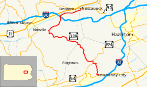
Pennsylvania Route 339 (PA 339) is a 32.8-mile-long (52.8 km), north–south state highway located in Schuylkill, Columbia, and Luzerne Counties in Pennsylvania. The southern terminus is at PA 54 in Mahanoy City. The northern terminus is at PA 93 in Nescopeck.
Route description
PA 339 along its route goes by multiple names. The names include Main Street, Creek Road, Catawissa Creek Road, State Road, Mainville Road, Main Mifflin Drive, Third Street, and Broad Street. Though signed north–south, the route from Mahanoy City to the village of Mainville goes southeast-northwest, and from the village of Mifflinville to Nescopeck, primarily east–west.[2]
The route starts at an intersection with PA 54 in Mahanoy City, and heads north to the village of Brandonville, where it has a short concurrency with PA 924 to the village of Girard Manor. The route then continues to the northwest.
The route continues to the northwest to the village of Mainville, where it makes its turn to the northeast. In the village of Mifflinville, I-80 has an interchange with the route. After crossing through Mifflinville, the route heads east, and parallels the Susquehanna River.
The route continues east for a short distance before making a turn north to the town of Nescopeck, where it terminates at PA 93.
History
Signed in 1928 from Bloomsburg, to Benton,[3] the route was paved in its entirety through the 1930s. Parts of the route were signed different during the years, as PA 44, PA 242 and PA 342. In the 1960s, the route was moved around, with its southern terminus eventually being placed in Mahanoy City, and its northern terminus eventually being placed in Nescopeck.[4]
Major intersections
| County | Location | mi[1] | km | Destinations | Notes |
|---|---|---|---|---|---|
| Schuylkill | Mahanoy City | 0.000 | 0.000 | ||
| East Union Township | 4.338 | 6.981 | South end of PA 924 concurrency | ||
| 5.014 | 8.069 | North end of PA 924 concurrency | |||
| Columbia | Mifflin Township | 26.794– 26.952 | 43.121– 43.375 | Exit 242 (I-80) | |
| Luzerne | Nescopeck | 32.840 | 52.851 | ||
1.000 mi = 1.609 km; 1.000 km = 0.621 mi
| |||||
See also
- U.S. Roads portal
- Pennsylvania portal
References
- ↑ 1.0 1.1 "Pennsylvania state roads". Pennsylvania Spatial Data Access. Pennsylvania Department of Transportation. 2013. Retrieved March 14, 2013.
- ↑ ftp://ftp.dot.state.pa.us/public/pdf/BPR_PDF_FILES/MAPS/Statewide/otm/2007/otmne_2007.PDF
- ↑ ftp://ftp.dot.state.pa.us/public/pdf/BPR_pdf_files/Maps/Statewide/Historic_OTMs/1930fr.pdf
- ↑ ftp://ftp.dot.state.pa.us/public/pdf/BPR_pdf_files/Maps/Statewide/Historic_OTMs/1970fr.pdf
External links
Route map: Bing
| Wikimedia Commons has media related to Pennsylvania Route 339. |