Pennsylvania Route 274
| ||||
|---|---|---|---|---|
 | ||||
| Route information | ||||
| Maintained by PennDOT | ||||
| Length: | 43.8 mi[1] (70.5 km) | |||
| Major junctions | ||||
| West end: |
| |||
|
| ||||
| East end: |
| |||
| Location | ||||
| Counties: | Franklin, Perry | |||
| Highway system | ||||
| ||||

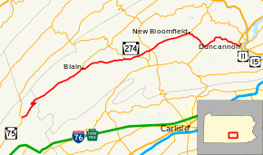
Pennsylvania Route 274 (PA 274) is a 44-mile-long (71 km) state highway located in Franklin and Perry Counties in Pennsylvania. The western terminus is at PA 75 in Fannett Township. The eastern terminus is at US 11/US 15 in Duncannon.
Route description
PA 274 begins at an intersection with PA 75 in Fannett Township, Franklin County, heading northeast on two-lane undivided Big Spring Road. The road heads through a mix of farmland and woodland with some homes before ascending forested Conococheague Mountain.[1][2] The route heads into the Tuscarora State Forest and enters Toboyne Township in Perry County and becomes an unnamed road, making a hairpin turn to the southwest before another hairpin turn to the northeast to descend the mountain, passing by Big Spring State Forest Picnic Area. PA 274 runs through more of Tuscarora State Forest before leaving the forest boundaries and heading into open agricultural areas with some homes, passing through New Germantown. The road enters Jackson Township and becomes Mt. Pleasant Road, coming to Mt. Pleasant and becoming an unnamed road again. The route heads into Blain and passes homes, reaching an intersection with PA 17 and turns southeast onto Main Street. PA 274 curves to the east and heads back into Jackson Township, turning northeast into more open farmland as an unnamed road. The road crosses into Southwest Madison Township and curves more to the east, running through Andersonburg. The route heads through more rural areas and passes through Cisna Run and Centar. PA 274 heads through farmland with some woods to the south as it continues into Northeast Madison Township and intersects PA 850 in Fort Robinson.[1][3]
At this point, PA 274 forms a concurrency with PA 850 and the two routes head east on Shermans Valley Road, passing through a mix of farms and woods and crossing into Tyrone Township. The road heads through agricultural areas with some homes before coming into the community of Loysville, where PA 850 splits from PA 274 by heading to the southeast. From here, the route heads east-northeast through areas of farms with homes, coming to an intersection with the northern terminus of PA 233 in Green Park. A short distance later, the road heads into Spring Township and crosses PA 74. Past this intersection, PA 274 continues through more agricultural areas with some residences, passing through Elliottsburg and Dunn. The road enters Centre Township and continues through more rural areas.[1][3]
The route heads into Bloomfield and becomes West Main Street, passing homes. PA 274 heads into the downtown area and comes to a traffic circle, where it intersects PA 34. At this point, PA 34 continues east on Main Street and PA 274 turns south to join PA 34 on South Carlisle Street, running past more residences. The road turns east to head back into Centre Township and become Spring Road, winding southeast through farms, woods, and residences. PA 34/PA 274 becomes the border between Carroll Township to the west and Wheatfield Township to the east, heading through agricultural areas with a few homes before continuing into forests. In Mecks Corner, PA 274 splits from PA 34 by heading southeast onto Bloomfield Road into Wheatfield Township, soon curving to the northeast. The route heads through wooded areas with some fields and homes, turning east. The road continues through more agricultural areas with some woodland and residences, heading southeast and passing through Roseglen. PA 274 enters Penn Township and heads through more rural areas with some residential development. The route becomes the border between Duncannon to the north and Penn Township to the south before ending at an interchange with the US 11/US 15 freeway. From here, the road continues northeast into Duncannon as South Market Street.[1][3]
Major intersections
| County | Location | mi | km | Destinations | Notes |
|---|---|---|---|---|---|
| Franklin | Fannett Township | 0.00 | 0.00 | Western terminus | |
| Perry | Blain | Western terminus of PA 17 | |||
| Northeast Madison Township | West end of PA 850 concurrency | ||||
| Tyrone Township | East end of PA 850 concurrency | ||||
| Northern terminus of PA 233 | |||||
| Spring Township | |||||
| Bloomfield | West end of PA 34 concurrency | ||||
| Carroll Township | West end of PA 34 concurrency | ||||
| Duncannon | Interchange, eastern terminus | ||||
| 1.000 mi = 1.609 km; 1.000 km = 0.621 mi | |||||
See also
- U.S. Roads portal
- Pennsylvania portal
References
Route map: Bing
- ↑ 1.0 1.1 1.2 1.3 1.4 Google (June 16, 2011). "overview of Pennsylvania Route 274" (Map). Google Maps. Google. Retrieved June 16, 2011.
- ↑ Franklin County, Pennsylvania Highway Map (PDF) (Map). PennDOT. 2011. Retrieved March 8, 2011.
- ↑ 3.0 3.1 3.2 Perry County, Pennsylvania Highway Map (PDF) (Map). PennDOT. 2011. Retrieved June 10, 2011.