Pennsylvania Route 262
| ||||
|---|---|---|---|---|
 | ||||
| Route information | ||||
| Maintained by PennDOT | ||||
| Length: | 11.9 mi[1] (19.2 km) | |||
| Existed: | 1961 – present | |||
| Major junctions | ||||
| West end: |
| |||
|
| ||||
| East end: |
| |||
| Location | ||||
| Counties: | York | |||
| Highway system | ||||
| ||||

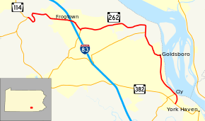
Pennsylvania Route 262 (PA 262) is an 11.9-mile-long (19.2 km) state highway located in York County, Pennsylvania. The western terminus is at PA 114 in Fairview Township. The eastern terminus is at PA 382 near York Haven.
Route description
PA 262 begins at an intersection with PA 114 in the community of Bunches in Fairview Township, heading southeast on two-lane undivided Fishing Creek Road. The route heads through wooded areas of homes and makes a hairpin turn to the northwest to ascend a hill. The road makes a sharp turn to the east and descends the hill, passing homes in the communities of Springville and Frogtown. Farther east, PA 262 enters commercial areas and reaches an interchange with I-83. Past here, the route turns southeast and merges onto Old York Road. PA 262 continues past more homes and businesses before intersecting PA 177, at which point that route continues along Old York Road and PA 262 turns east onto Valley Road. The road heads into a mix of farms and housing developments, eventually becoming the border between Fairview Township to the north and Newberry Township to the south, entering open farmland. After fully entering Newberry Township, the route makes a sharp turn to the south and intersects PA 392 in the community of Plainfield. PA 262 passes more agricultural areas before passing near a housing subdivision and becoming the border between Newberry Township to the west and Goldsboro to the east.[1][2]
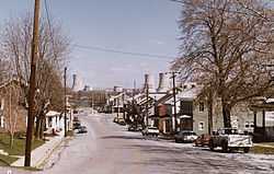
The route turns to the east to descend a hill and fully enter Goldsboro, becoming Broadway Avenue as it is lined with homes. At the town square, PA 262 turns south onto York Street and passes more residences. The road leaves Goldsboro for Newberry Township again and becomes Cly Road as it continues through a mix of woods and homes. The route turns southeast through forests and parallels a Norfolk Southern railroad line along the Susquehanna River, reaching a junction with PA 295 in the residential community of Cly. From here, PA 262 turns south away from the railroad line and river, passing forested areas of homes as it comes to its terminus at PA 382.[1][2]
Major intersections
The entire route is in York County.
| Location | mi | km | Destinations | Notes | |
|---|---|---|---|---|---|
| Fairview Township | 0.0 | 0.0 | |||
| Exit 36 (I-83) | |||||
| Newberry Township | Eastern terminus of PA 392 | ||||
| Eastern terminus of PA 295 | |||||
| 1.000 mi = 1.609 km; 1.000 km = 0.621 mi | |||||
See also
- U.S. Roads portal
- Pennsylvania portal
References
Route map: Bing
- ↑ 1.0 1.1 1.2 Google (February 23, 2011). "overview of Pennsylvania Route 262" (Map). Google Maps. Google. Retrieved February 23, 2011.
- ↑ 2.0 2.1 York County, Pennsylvania Highway Map (PDF) (Map). PennDOT. 2011. Retrieved February 22, 2011.