Pennsylvania Route 234
| ||||
|---|---|---|---|---|
 | ||||
| Route information | ||||
| Maintained by PennDOT | ||||
| Length: | 38.3 mi[1] (61.6 km) | |||
| Major junctions | ||||
| West end: |
| |||
|
| ||||
| East end: |
| |||
| Location | ||||
| Counties: | Adams, York | |||
| Highway system | ||||
| ||||

Pennsylvania Route 234 (PA 234) is a 38-mile-long (61 km) state highway located in Adams and York Counties in Pennsylvania. The western terminus is at US 30 in Franklin Township. The eastern terminus is at PA 462 in West York. Right before its eastern terminus, PA 234 crosses US 30 on an overpass; however, there is no direct access to the highway.
Route description
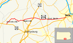
PA 234 begins at an intersection with US 30 in Franklin Township, Adams County, heading north on two-lane undivided Buchanan Valley Road. The road runs through farms and forests with some homes, turning northeast and passing through Trust. The route continues through rural areas as it curves more to the east and winds through forests along the Conewago Creek, eventually crossing the creek into Menallen Township. PA 234 continues southeast a short distance to the northeast of the creek on Narrows Road. The road crosses the creek again and heads back into Franklin Township, passing through Bridgeport and heading east before turning south in agricultural areas with a few homes. The route enters Arendtsville and becomes North High Street, passing homes. PA 234 turns east onto Main Street and continues through more residential areas. The road crosses the Conewago Creek into Butler Township and becomes Arendtsville Road, running through open farmland with a few homes. The route heads into Biglerville and intersects the western terminus of PA 394, becoming West York Street and passing residences. The road becomes East York Street and crosses PA 34, continuing east and crossing the Gettysburg and Northern Railroad.[1][2]
PA 234 turns northeast and heads back into Butler Township, becoming Heidlersburg Road and running through more open agricultural areas with occasional homes. The road curves more to the east and crosses into Tyrone Township, running through more rural areas. The route passes through Heidlersburg and continues to an interchange with the US 15 freeway. From here, PA 234 runs through a mix of farmland and woodland with some residences on East Berlin Road, becoming the border between Huntington Township to the north and Tyrone Township to the south as it heads through Five Points. From this point, the road becomes the border between Reading Township to the north and Tyrone Township to the south, briefly heading entirely into Tyrone Township prior to crossing the Plum Run into Reading Township. In this area, the route crosses PA 94 before continuing east through more agricultural areas. PA 234 crosses the Conewago Creek into East Berlin and becomes West King Street, passing homes along with a few businesses. In the center of town, the route intersects PA 194 and becomes East King Street.[1][2]
PA 234 crosses into Paradise Township in York County and becomes East Berlin Road, heading east through more farmland with a few homes. The road runs through more rural areas as it passes through Jackson Township. The route briefly passes through Dover Township before crossing the Honey Run into West Manchester Township. In this area, PA 234 runs through more agricultural areas as it passes to the north of a quarry. The road comes to a bridge over the US 30 freeway and heads into industrial areas. Farther east, PA 234 heads into residential areas and comes to its eastern terminus at PA 462 just outside the borough of West York.[1][3]
Major intersections
| County | Location | mi | km | Destinations | Notes |
|---|---|---|---|---|---|
| Adams | Franklin Township | Western terminus | |||
| Biglerville | Western terminus of PA 394 | ||||
| Tyrone Township | Interchange | ||||
| Reading Township | |||||
| East Berlin | |||||
| York | West York | Eastern terminus | |||
| 1.000 mi = 1.609 km; 1.000 km = 0.621 mi | |||||
See also
- U.S. Roads portal
- Pennsylvania portal
References
Route map: Bing
- ↑ 1.0 1.1 1.2 1.3 Google (June 6, 2011). "overview of Pennsylvania Route 234" (Map). Google Maps. Google. Retrieved June 6, 2011.
- ↑ 2.0 2.1 Adams County, Pennsylvania Highway Map (PDF) (Map). PennDOT. 2011. Retrieved February 22, 2011.
- ↑ York County, Pennsylvania Highway Map (PDF) (Map). PennDOT. 2011. Retrieved February 22, 2011.