Pennsylvania Route 196
| ||||
|---|---|---|---|---|
 | ||||
| Route information | ||||
| Maintained by PennDOT | ||||
| Length: | 25.7 mi[1] (41.4 km) | |||
| Major junctions | ||||
| South end: |
| |||
| North end: |
| |||
| Location | ||||
| Counties: | Monroe, Wayne | |||
| Highway system | ||||
| ||||

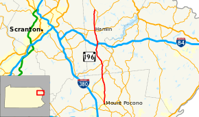
Pennsylvania Route 196 (PA 196) is a state highway in Pocono Mountains of Pennsylvania with a length of 25.7 miles (41.4 km). It runs from Pennsylvania Route 940 and Pennsylvania Route 611 in Mount Pocono to Pennsylvania Route 296 in Varden.
Route description
Pennsylvania Route 196 starts as Sterling Road at an intersection with PA 611 and PA 940. From this intersection, the highway heads north through Monroe County, intersecting with PA 423 in Tobyhanna.
PA 196 continues as Sterling Road into Wayne County, and intersects PA 507 in the town of Angels. Just after crossing under Interstate 84, PA 196 intersects PA 191, which provides access to the interstate at Exit 17. PA 196 and PA 191 then overlap northward toward the town of Hamlin, where they intersect PA 590. In Lake Township, PA 196 and PA 191 split. PA 196 ends at PA 296 in Varden.
Major intersections
| County | Location | mi | km | Destinations | Notes |
|---|---|---|---|---|---|
| Monroe | Mount Pocono | 0.0 | 0.0 | Southern terminus of PA 196. | |
| Coolbaugh Township | 7.0 | 11.3 | |||
| Wayne | Dreher Township | 10.8 | 17.4 | ||
| Sterling Township | 16.3 | 26.2 | No access between PA 196 and I-84. | ||
| 17.2 | 27.7 | South end of overlap with PA 191. | |||
| Salem Township | 20.1 | 32.3 | |||
| Lake Township | 21.2 | 34.1 | North end of overlap with PA 191. | ||
| South Canaan Township | 25.7 | 41.4 | Northern terminus of PA 196. | ||
1.000 mi = 1.609 km; 1.000 km = 0.621 mi
| |||||
See also
- U.S. Roads portal
- Pennsylvania portal
References
- ↑ Google (May 18, 2013). "Pennsylvania Route 196" (Map). Google Maps. Google. Retrieved May 18, 2013.