Pennsylvania Route 194
| ||||
|---|---|---|---|---|
 | ||||
| Route information | ||||
| Maintained by PennDOT | ||||
| Length: | 31.9 mi[1] (51.3 km) | |||
| Major junctions | ||||
| South end: |
| |||
|
| ||||
| North end: |
| |||
| Location | ||||
| Counties: | Adams, York | |||
| Highway system | ||||
| ||||

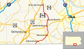
Pennsylvania Route 194 (PA 194) is a 31-mile-long (50 km) north–south state highway located in south-central Pennsylvania. The southern end is at the Maryland State Line (where it continues south as Maryland Route 194) and the northern terminus is at the intersection with PA 74 in the town of Dillsburg.
Route description

PA 194 begins at the Maryland border in Germany Township, Adams County, heading northeast on two-lane undivided Frederick Pike. The road continues south into Maryland as MD 194. From the state line, the route passes through agricultural areas with a few residences and patches of woods. PA 194 turns northeast and enters Littlestown, running past a few businesses and heading into residential areas as King Street. The road heads east-northeast into the commercial downtown and intersects PA 97. Past this area, the route passes more homes and leaves Littlestown for Union Township, becoming Hanover Pike. PA 194 continues into farmland with some woods and residences, turning northeast again. The road passes through Lefevre and crosses the South Branch of the Conewago Creek into Conewago Township. The route runs through more agricultural surroundings and passes through Mount Pleasant.[1][2]
PA 194 enters Penn Township in York County and becomes Frederick Street as it becomes lined with homes, continuing into Hanover. Upon reaching the Forney Avenue intersection, the route splits into a one-way pair with northbound PA 194 continuing along two-way Frederick Street and southbound PA 194 using Forney Avenue to one-way Chestnut Street. Both streets pass a mix of homes and businesses, continuing into the downtown area of Hanover. In this area, the route meets PA 116 and forms a concurrency with that route. In the commercial center, the one-way pair crosses PA 94, with northbound PA 194/PA 116 becoming Broadway at this point. A short distance later, PA 116 splits from PA 194 by turning east onto York Street, with northbound PA 194 continuing north as a one-way street. The one-way pair passes rowhomes, eventually merging with the route continuing north on two-way Broadway. The road crosses CSX and York Railway rail lines as it continues past a mix of residential and commercial buildings before becoming lined with homes. After intersecting Moulstown Road, PA 194 crosses back into Penn Township and becomes Abbottstown Pike as it enters agricultural areas with scattered development.[1][3]
As the route enters more forested areas with some homes, it enters Berwick Township in Adams County and heads north through farmland and housing developments. PA 194 continues through a mix of hilly farms, woods, and homes before reaching Abbottstown. Here, the road becomes Queen Street and passes homes, intersecting US 30 in the center of town at a roundabout. After leaving Abbottstown, the route enters farmland, briefly passing through Berwick Township again as an unnamed road before continuing into Hamilton Township. The road runs through agricultural areas with scattered residential developments. Upon entering East Berlin, PA 194 becomes Abbottstown Street and passes homes. Upon crossing PA 234 in the center of town, the route becomes Harrisburg Street and crosses the Conewago Creek, heading through a small portion of Reading Township.[1][2]
PA 194 enters Washington Township in York County and continues north through more farmland with some homes and woods as Baltimore Pike. The road turns northwest and enters a mix of agricultural areas and woodland. After crossing the Bermudian Creek, the route heads north again into more areas of farms along with a few patches of trees and homes. PA 194 eventually crosses into Franklin Township before continuing into Franklintown, where the road is lined with homes and is known as Baltimore Road. Upon leaving Franklintown, the route briefly enters Franklin Township again before crossing into Carroll Township and becoming Baltimore Street as it passes through more rural areas. PA 194 reaches its northern terminus at an intersection with PA 74 to the south of Dillsburg.[1][3]
Major intersections
| County | Location | mi | km | Destinations | Notes |
|---|---|---|---|---|---|
| Adams | Maryland state line | 0.0 | 0.0 | Southern terminus, continues as MD 194 | |
| Littlestown | 2.7 | 4.3 | |||
| York | Hanover | 9.8 | 15.8 | South end of PA 116 concurrency | |
| 9.9 | 15.9 | ||||
| 10.0 | 16.1 | North end of PA 116 concurrency | |||
| Adams | Abbottstown | 16.1 | 25.9 | ||
| East Berlin | 19.7 | 31.7 | |||
| York | Dillsburg | 31.9 | 51.3 | Northern terminus | |
1.000 mi = 1.609 km; 1.000 km = 0.621 mi
| |||||
See also
- U.S. Roads portal
- Pennsylvania portal
References
- ↑ 1.0 1.1 1.2 1.3 1.4 Google (February 22, 2011). "overview of Pennsylvania Route 194" (Map). Google Maps. Google. Retrieved February 22, 2011.
- ↑ 2.0 2.1 Adams County, Pennsylvania Highway Map (PDF) (Map). PennDOT. 2011. Retrieved February 22, 2011.
- ↑ 3.0 3.1 York County, Pennsylvania Highway Map (PDF) (Map). PennDOT. 2011. Retrieved February 22, 2011.
External links
| Wikimedia Commons has media related to Pennsylvania Route 194. |