Pennsylvania Route 17
| ||||
|---|---|---|---|---|
 | ||||
| Route information | ||||
| Maintained by PennDOT | ||||
| Length: | 35.689 mi[1] (57.436 km) | |||
| Major junctions | ||||
| West end: |
| |||
|
| ||||
| East end: |
| |||
| Location | ||||
| Counties: | Perry | |||
| Highway system | ||||
| ||||

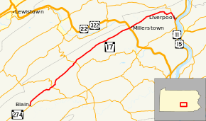
Pennsylvania Route 17 (PA 17) is a state highway located entirely in Perry County, Pennsylvania. The route is 35.7 miles (57.5 km) long and is signed east and west.
The western terminus of the route is at PA 274 in Blain. The eastern terminus is at U.S. Routes 11 and 15 in Liverpool.
Route description
PA 17 begins in Blain at the intersection of PA 274, heading northwest on a two-lane undivided road. The route passes homes and turns north, crossing into Jackson Township. The road heads into open agricultural areas with a few homes, curving to the northeast. PA 17 crosses into Southwest Madison Township and runs through more farmland with some woods and residences, passing through Hench and Stony Point. The route turns east and enters Northeast Madison Township, coming to Pine Grove and curving northeast again. The road forms a brief concurrency with PA 850 in Kistler and becomes Tuscarora Path, running through more agricultural areas with occasional homes and heading more to the north. PA 17 curves northeast and heads into Saville Township, passing through more rural areas. The route curves northwest before turning northeast onto Raccoon Valley Road and heading into the residential community of Ickesburg, where it crosses PA 74. Past here, the road runs through more farmland with some woods, crossing into Tuscarora Township. In this area, PA 17 runs through wooded areas with some fields before heading into a narrow agricultural valley with a few homes. The route runs through more rural areas, passing through Donnally Mills and Gramere.[2][3]
The route crosses a bridge over the Juniata River and then passes under U.S. Routes 22 and 322 as it enters Millerstown and becomes West Sunbury Street. The route passes businesses in the center of town before continuing into residential areas as East Sunbury Street. The route continues into Greenwood Township and becomes Sunbury Path, as noted by open farmland. The road crosses the Cocolamus Creek and runs through more agricultural areas with some woods and homes. PA 17 passes through more open farmland as it continues into Liverpool Township. The route, bearing the name of Pennsylvania Route 17 in this area, cuts through forested areas and later through a gap in Wildcat Ridge. Next, the route turns east through more woods and comes to a junction with PA 235. From this junction east, Route 235 runs concurrently with Route 17, as both routes continue south before entering Liverpool and terminating at U.S. Routes 11 and 15.[2][3]
History
PA 17 was first designated by 1930 on its current alignment between Millerstown and Liverpool.[4] The modern-day route of PA 17 between Ickesburg and Millerstown was designated PA 74.[4] By 1940, the route was moved onto its current alignment between Blain and Liverpool.[5] No major changes have occurred since then.[3]
Major intersections
The entire route is in Perry County.
| Location | mi[1] | km | Destinations | Notes | |
|---|---|---|---|---|---|
| Blain | 0.000 | 0.000 | |||
| Northeast Madison Township | 5.907 | 9.506 | |||
| Saville Township | 12.562 | 20.217 | |||
| Liverpool Township | 34.024 | 54.756 | End of signage for PA 235, PA 235 concurrency with PA 17 begins east of intersection | ||
| Liverpool | 35.689 | 57.436 | Official eastern terminus of PA 17 and southern terminus of PA 235 | ||
| 1.000 mi = 1.609 km; 1.000 km = 0.621 mi | |||||
See also
- U.S. Roads portal
- Pennsylvania portal
References
Route map: Bing
- ↑ 1.0 1.1 Bureau of Maintenance and Operations (December 31, 2012). "Roadway Management System Straight Line Diagrams" (January 2013 ed.). Pennsylvania Department of Transportation. Retrieved February 23, 2014.
- Perry County (PDF)
- ↑ 2.0 2.1 Google (June 17, 2011). "overview of Pennsylvania Route 17" (Map). Google Maps. Google. Retrieved June 17, 2011.
- ↑ 3.0 3.1 3.2 Perry County, Pennsylvania Highway Map (PDF) (Map). PennDOT. 2011. Retrieved June 10, 2011.
- ↑ 4.0 4.1 Tourist Map of Pennsylvania (PDF) (Map). Pennsylvania Department of Highways. 1930. Retrieved February 23, 2014.
- ↑ Official Road Map of Pennsylvania (PDF) (Map). Pennsylvania Department of Highways. 1940. Retrieved February 23, 2014.