Pennsylvania Route 163
| ||||
|---|---|---|---|---|
|
Pennsylvania Route 163 highlighted in red | ||||
| Route information | ||||
| Maintained by PennDOT | ||||
| Length: | 2.384 mi[1] (3.837 km) | |||
| Major junctions | ||||
| West end: |
| |||
|
| ||||
| East end: |
| |||
| Location | ||||
| Counties: | Franklin | |||
| Highway system | ||||
| ||||

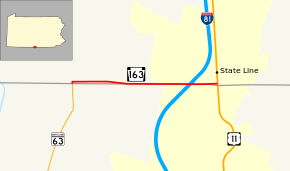
Pennsylvania Route 163 (PA 163) is a state highway in the U.S. state of Pennsylvania. Known for most of its length as Mason Dixon Road, the state highway runs 2.384 miles (3.837 km) from the Maryland state line, where the highway continues south as Maryland Route 63 (MD 63), east to U.S. Route 11 (US 11) in Antrim Township in southern Franklin County.
Route description
PA 163 begins at the Maryland state line in Antrim Township. The roadway continues south as MD 63 (Greencastle Pike) toward Cearfoss and Williamsport. PA 163 begins heading north from the state line, then immediately turns east onto Mason Dixon Road. The roadway continues straight as SR 3001 (Williamsport Pike) toward Greencastle. PA 163 parallels the north side of the Maryland–Pennsylvania state line at a distance of about 200 feet (61 m) at Williamsport Pike. The distance reduces to less than 50 feet (15 m) after the state highway crosses Norfolk Southern Railway's Lurgan Branch at-grade. PA 163 continues east through farmland, intersecting Maugansville Road on the Maryland side before reaching its interchange with I-81 (American Legion Memorial Highway). The ramps to and from southbound I-81 are on the Maryland side of the highway, while the ramps to and from northbound I-81 are in Pennsylvania. PA 163 continues east into the unincorporated village of State Line where the highway reaches its eastern terminus at US 11 (Molly Pitcher Highway) just north of where US 11 enters Maryland.[1][2][3]
Major intersections
The entire route is in Antrim Township, Franklin County.
| mi[1] | km | Destinations | Notes | ||
|---|---|---|---|---|---|
| 0.000 | 0.000 | Western terminus; Maryland state line | |||
| 0.026 | 0.042 | SR 3001 (Williamsport Pike) – Greencastle | PA 163 turns east onto Mason Dixon Road | ||
| 1.909 | 3.072 | I-81 Exit 1; southbound I-81 ramps are in Maryland and northbound I-81 ramps are in Pennsylvania | |||
| 2.384 | 3.837 | Eastern terminus | |||
| 1.000 mi = 1.609 km; 1.000 km = 0.621 mi | |||||
See also
- U.S. Roads portal
- Pennsylvania portal
References
- ↑ 1.0 1.1 1.2 Bureau of Maintenance and Operations (December 31, 2012). "Roadway Management System Straight Line Diagrams" (2013 ed.). Pennsylvania Department of Transportation. Retrieved 2013-09-05.
- Franklin County (PDF)
- ↑ General Highway Map: Franklin County, Pennsylvania (PDF) (Map) (2010 ed.). Pennsylvania Department of Transportation. Retrieved 2010-11-18.
- ↑ Google (2010-11-18). "Pennsylvania Route 163" (Map). Google Maps. Google. Retrieved 2010-11-18.
External links
Route map: Bing